GeoCV Beta release - UNLIMITED PLAN, WHITE LABEL, SELF-HOST, OWN COPYRIGHT8598
 GeoCV GeoCVCo-Founder New York City |
AntonYakubenko private msg quote post Address this user | |
| Dear community members, I'm excited to announce that we're releasing GeoCV solution for capturing and visualizing spaces in 3D+360° in beta! We've received significantly more responses to our survey and email blasts than we anticipated. We'll be reaching out to these early adopters in the coming days with particular proposals including pricing info. The highlights of GeoCV solution include: - UNLIMITED PLAN: unlimited processing + unlimited hosting + unlimited floor plans for a flat fee per camera per month (or per year) - White labeling - Self-hosting - Customers own the copyrights for delivered content - Download of full-resolution 3D model and 360° panoramas - Content editing and re-upload - Offline viewing for PC and Mac - Password protection for 3D tours access Our capturing features: - Small and lightweight scanning kit, carrying case included - Scanning kit comes with everything required, you only need a tripod - Fast and easy training, FaceTime remote training for early adopters - Easy-to-use solution not prone to human mistakes - Real-time feedback during scanning (preview of captured space) - Optional HD capturing - Automatic processing in the cloud - Web dashboard to edit 3D tours Our viewer features: - Realistic 3D scan view - High-resolution HDR 360° panoramas - Walkthrough with smooth transitions - Floor plan with dimensions integrated into 3D tour - White labeled floor plan delivered as file in black & white and textured versions - Info block with space address, parameters and description, client contact information, photo and logo - Pins (annotations) with rich media content - Standalone 360° panoramas added as viewpoints (e.g. for outdoor or amenities) - Short custom URLs, optional MLS compliant unbranded version of 3D tour - Optional 3D and 2D interactive minimap in walkthrough mode - Zoom for HD 3D tours - Clean, sleek, minimalistic design - Support of the absolute majority of devices and browsers (both desktop and mobile) Plus custom projects premium features: - Integration of exterior 3D and 360° visuals captured with a drone - Virtually staged 3D tours - Video narration dependent on room We have been in the shoes of a service provider by ourselves. Now we're passing our service business in NYC to independent third-party service providers. We want to empower service providers to avoid a race to the bottom with squeezing margins by providing you more differentiation and control over data and viewing experience. Our unlimited pricing plan and such features as white labeling, branding and self-hosting should allow you to make 3D tours a standard part of your growing business. While we scale our production and iterate on product improvement based on early adopters feedback, we will be offering our solution in limited quantities. Please drop us a line at info@geocv.com or simply fill in "Contact Us" form on our website to join the waitlist. Our website is legacy and will be updated with more information about GeoCV solution. The whole GeoCV team and I personally are very excited and look forward to your GeoCV 3D tours and feedback. I want to sincerely thank you for your patience and continuous support. Let's join forces to capture the world in 3D, one space at a time! |
||
| Post 1 • IP flag post | ||

|
PedroPretell private msg quote post Address this user | |
| looks great! I just filled out the contact us form, looking foward to trying out the beta. | ||
| Post 2 • IP flag post | ||

|
immersivespaces private msg quote post Address this user | |
| @AntonYakubenko Question... will the floorplans be available in vector format? | ||
| Post 3 • IP flag post | ||
 WGAN Basic WGAN BasicMember Reading, United Kingdom |
mcuddy private msg quote post Address this user | |
| Hi Anton, I’ve dropped you a message on LinkedIn around a particular application requirement. Looking forward to your response. |
||
| Post 4 • IP flag post | ||

Frisco, Texas |
Metroplex360 private msg quote post Address this user | |
| What resolution are the panos? What camera is included with the subscription? How much is the subscription? |
||
| Post 5 • IP flag post | ||

|
Shakoure private msg quote post Address this user | |
| @AntonYakubenko Nice, I really like it... But what happen with the proprietary issues with MP? Did you guys settle? | ||
| Post 6 • IP flag post | ||

|
DouglasMeyers private msg quote post Address this user | |
| I think we are all now asking how do we jump on board ? Thanks Douglas |
||
| Post 7 • IP flag post | ||
 GeoCV GeoCVCo-Founder New York City |
AntonYakubenko private msg quote post Address this user | |
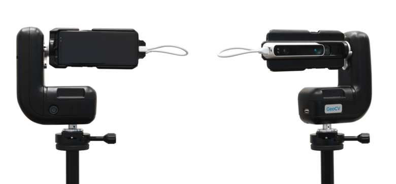
Quote:Originally Posted by Metroplex360 We have 2 options: 1. SD - 6434 x 3217 2. HD - 12868 x 6434 The majority of GeoCV 3D tours you've seen are in SD resolution. So if you liked them, you'll like HD even better. HD resolution allows extraction of print quality still photos. It also allows zoom in 3D tours. I'd stress that one should differentiate between formal megapixels used for marketing and actual level of detail and crispiness. The latter depends a lot on software, both during processing and visualization. Quote: Originally Posted by Metroplex360 You recieve a whole GeoCV scanning kit including: - Samsung Galaxy S8 smartphone - Occipital Structure 3D sensor attachment - Proprietary rotator - Carrying case - Batteries, chargers, cables - Arca-Swiss quick-release clamp The only thing you'll need on top of that is a regular tripod, which might not be heavy duty since the camera weighs only 3 lb. Here is how it looks now:  Quote: Originally Posted by Metroplex360 We'll be sending out pricing to our potential customers via email. |
||
| Post 8 • IP flag post | ||
 GeoCV GeoCVCo-Founder New York City |
AntonYakubenko private msg quote post Address this user | |
Quote:Originally Posted by Shakoure The litigation process has started and could take like a couple of years. In parallel we're in negotiations to resolve the litigation. |
||
| Post 9 • IP flag post | ||
 GeoCV GeoCVCo-Founder New York City |
AntonYakubenko private msg quote post Address this user | |
Quote:Originally Posted by DouglasMeyers Just reach out to us via info@geocv.com or fill in "Contact Us" form on our website https://geocv.com. You'll be added to the list, and we'll be reaching out back to you soon enough. |
||
| Post 10 • IP flag post | ||

|
DouglasMeyers private msg quote post Address this user | |
| What if we have a Samsung S9 and the Structure ? | ||
| Post 11 • IP flag post | ||
 GeoCV GeoCVCo-Founder New York City |
AntonYakubenko private msg quote post Address this user | |
Quote:Originally Posted by DouglasMeyers Currently we provide the whole kit including pre-calibrated smartphone and sensor. Support for customers' phones would be available later this year, but not in short-term. But you're free to use the provided the smartphone outside of the scanner kit as a regular phone. It could be easily plugged in and out. |
||
| Post 12 • IP flag post | ||

|
Shakoure private msg quote post Address this user | |
| @AntonYakubenko ...Hope it turns out amicably. Other than that, things seem to be moving pretty well since our talk at Ascent. Wish you guys the best. | ||
| Post 13 • IP flag post | ||

|
rzphotoman private msg quote post Address this user | |
| I really like what I'm seeing and so have a few of my clients that I've shown your examples to. Sent in my request for your beta release service...hope to hear back from you soon. Great job! | ||
| Post 14 • IP flag post | ||

|
Shakoure private msg quote post Address this user | |
| @AntonYakubenko ...Any SDK possibilities for developers? | ||
| Post 15 • IP flag post | ||

|
annevanzwol private msg quote post Address this user | |
| @AntonYakubenko Two questions 1. Some time ago I signed up for the beta program. When can I expect your email with further details? 2. Can you share an example of the GeoCV’s performance in outside sunligh situations? Looking forward to testing GeoCV. |
||
| Post 16 • IP flag post | ||
 GeoCV GeoCVCo-Founder New York City |
AntonYakubenko private msg quote post Address this user | |
Quote:Originally Posted by Shakoure We have this in our longer-term product roadmap. And while it's not yet available, we're interested to learn what we could build in the product to make it even a better fit. |
||
| Post 17 • IP flag post | ||
 GeoCV GeoCVCo-Founder New York City |
AntonYakubenko private msg quote post Address this user | |
Quote:Originally Posted by annevanzwol Sorry for the delay and thank you for your patience. We've been a bit overwhelmed, but should send the follow-ups next week. Quote: Originally Posted by annevanzwol Sunlight is a problem for us now since Occipital Structure 3D sensor, which we use to get geometrical information, works in infrared light and thus doesn't perform well outdoors. If you want to capture 3D information shooting either in the shade, or closer to sunset, is the best option. Alternatively you can shoot outdoor panoramas at any lighting conditions and include them as viewpoints, i.e. standalone panoramas, not linked to the 3D scan. The latter approach could be also used to link 360 images of amenities, roof decks, etc. to the 3D tour. Here is an example comprising both approaches: |
||
| Post 18 • IP flag post | ||

|
manuqc private msg quote post Address this user | |
| Great work Anton! I've been following your company's work for some time now. I really like GeoCv's 3D viewer UI, very clean and modern interface, easy to read, as well as the possibility to have labeling in floorview mode. I am also very excited about the possibilities with exterior drone captures combined with interior 3D navigation to create cohesive inmersive experiences. As I've seen in the Halstead Real Estate project some time ago, very cool stuff. I understand that currently GeoCV's solution is using SG8 as it comes with custom calibration and settings you mentioned previously on this thread to process the tour properly. But in the future I could see that if other cameras were supported, GeoCV users could potentially shoot higher dynamic range photographic devices that allow us to capture higher bitdepth information to get better range to do color operations on images in post. Not sure if the panos are currently available in Jpeg only?. Once again, very excited with this news, I already sign up for the beta, hoping to get more details soon. Looking forward to try GeoCV solution. Regards, -Manuel |
||
| Post 19 • IP flag post | ||
 GeoCV GeoCVCo-Founder New York City |
AntonYakubenko private msg quote post Address this user | |
| Thank you, Manuel. Quote: Originally Posted by manuqc Yes, we'll support more capturing devices in the future. But even now we capture 7 exposures, so it covers a wide dynamic range. We provide panoramas in JPG, both the end processed ones and if required all exposures separately if you'd like to custom edit them, e.g. for better windows, highlights and shadows. |
||
| Post 20 • IP flag post | ||

|
AYODELE private msg quote post Address this user | |
| Well done Anton. Not quite sure if i signed up but I'd definitely not want to miss this. How do i sign up? Ayo. |
||
| Post 21 • IP flag post | ||

|
grmngrl private msg quote post Address this user | |
| @Metroplex360 Did you get answers to your question about pricing? | ||
| Post 22 • IP flag post | ||

|
manuqc private msg quote post Address this user | |
| Thanks for the answer Anton, Good to know you guys will plan to support more devices in the future. 7 exposures seems ok, (and understand the current 360 jpg will be fine for most people) but always preferable to have high range when possible prior assembling hdr (like in a .cr2 to ptgui 360 workflow) or to get a higher bitdepth 360 pano output to play instead of jpeg (ex: .exr, .hdr, 16 bit tiff) to do proper tone mapping and color balancing w/macbeth or similar. Once again props for the work on the 3D tour viewer hoping to keep seeing more cool ideas coming from your team. Keen to learn more about GeoCv's solution, waiting for the answer on the beta invite still. cheers, -Manuel |
||
| Post 23 • IP flag post | ||
 Founder FounderShow & Tour Leawood, Kansas |
JoshMais private msg quote post Address this user | |
| I have already applied and received the pricing but have a couple questions for Anton about some functionality. 1) Will the beta version include integration of exterior 3D and 360° visuals captured with a drone? If so, are there additional costs involved? 2) Can you give examples of an exported 360 view? Will you also be able to export still images? Can you provide an example? Thanks, Josh |
||
| Post 24 • IP flag post | ||
 GeoCV GeoCVCo-Founder New York City |
AntonYakubenko private msg quote post Address this user | |
Quote:Originally Posted by AYODELE Could you please PM your email, so we could follow-up without anything falling through the cracks? Thanks. |
||
| Post 25 • IP flag post | ||
 GeoCV GeoCVCo-Founder New York City |
AntonYakubenko private msg quote post Address this user | |
Quote:Originally Posted by grmngrl I'm not sure we have your email. Could you please share it via PM and we'll make sure to follow-up with pricing? Thank you. |
||
| Post 26 • IP flag post | ||
 GeoCV GeoCVCo-Founder New York City |
AntonYakubenko private msg quote post Address this user | |
Quote:Originally Posted by manuqc Got you, thank you for the feedback! Quote: Originally Posted by manuqc I really hope to scale to Canada sooner rather than later. |
||
| Post 27 • IP flag post | ||
 GeoCV GeoCVCo-Founder New York City |
AntonYakubenko private msg quote post Address this user | |
Quote:Originally Posted by sherpa_media Incorporation of exterior 3D scans and aerial 360 panoramas captured with a drone is our premium feature, which is not yet included into subscription and has project-base pricing in the range of several hundreds US dollars per tour. We do hope to automate it at some point to exclude extensive involvement of our post-production team, so it could be included into subscription or at least become more affordable. And the feedback from actual customers using it more and more would facilitate this. According to Inman such GeoCV 3D tours "blow minds", so it's worth the effort and investment at least for selected properties. It works as follows: - You need a regular drone with a good enough camera (for example, we used Phantom 4 Pro V2.0). - Flight automation software such as DroneDeploy is recommended. You should be also able to fly manually. - We provide you guidelines for shooting (see brief description below). You shoot and send us the images. - We use photogrammetric software to stitch them into 3D scan and optionally align 360 images to the 3D scan. - We align the exterior 3D scan with the interior 3D scan, and import all the content into GeoCV 3D tour. - The whole process might take several days. Here is the brief description of guidelines for shooting: - It includes automated regular grid trajectory for oblique and nadir shots, which could be automated via DroneDeploy software. This allows you to capture the main content for the house and its surroundings. We also recommend to additionally manually fly around the house in a few circles at multiple altitudes to provide better coverage, quality and level of detail. If flying at low altitudes is prohibitive, you might need to walk around the house with the drone in your hands. - For any trajectory, consequent images should have large, e.g. 80%, overlap. If possible, the whole house or its larger portions should be visible in the frame, unless these are the images for surroundings. Different flight sessions should have a large enough overlap in trajectory or coverage, e.g. they should start capturing from the approximately the same point. - You can optionally capture aerial 360 images, which we could integrate into GeoCV 3D tour both aligned to the exterior 3D scan and as highlights. You should use third-party software to capture and automatically stitch these images. We require both the stitched images and source frames for each panorama. - While shooting with a drone for photogrammetry is not that hard, it does require some skills and experience, so please be prepared for some trial and error learning curve. At least in the beginning until you master the skill, it might be a time consuming process, e.g. could take 2 hours, so it's recommended to have a few extra batteries fully charged before the shoot. Quote: Originally Posted by sherpa_media Yes and yes. We'll prepare and publish some samples of all exported deliverables including floor plans, 3D model, 360 panoramas and still photos. We're currently upgrading our app to shoot in HD, i.e. 4x higher resolution than you currently see in our 3D tours now, so we probably release these samples after such an upgrade. |
||
| Post 28 • IP flag post | ||

|
tour3dpl private msg quote post Address this user | |
| AntonYakubenko - there is chance to test GeoCV in Europe? I'm from Poland and want to participate. | ||
| Post 29 • IP flag post | ||

|
Kumar private msg quote post Address this user | |
| @AntonYakubenko, many confrontations on the rollout.... I must mention that I have been waiting for this very badly for year plus. MP is/was? monopoly in the market - ruling with it’s own terms. Most exciting propositions from geocv for me are, 1. Possibility of offline showcase - I don’t mind if you make it like a software player with license renewal. You still make your money recurring basis. 2. Hosting on own server 3. High res images for both tour and download 4. Mirror feature function live effect - you see the actual model being presented Couple questions to begin with, 1. What is the vertical fov? looks like a lot is compromised here (More than 40 deg?) - should this vary with different cam/phone? 2. I have filled in the form for pricing details (no acknowledgment and no response for it yet) 3. Any thought/possibility of post processing the content locally? - for instance where confidentiality is the priority where we are literally not allowed to take out the data from premises. Could work like a software with license key. 4. Post processing or processing of blk360? Or other Pro grade laser scanners 5. Why not get away with “powered by geoCV” once in the scene. The UI is so neat but for this line - I understand you have the white label option but still. 6. View options - as in typical CAD environment I very much miss this feature. It is so convenient to have standard views to choose from. Just the top and orbit are not handy. Best wishes and I sincerely wish that the legal course will be in favor and we all benefit equally. |
||
| Post 30 • IP flag post | ||


