Will Matterport Charge for Publish to GSV?6120
Pages:
1
 WGAN Forum WGAN ForumFounder & WGAN-TV Podcast Host Atlanta, Georgia |
DanSmigrod private msg quote post Address this user | |
| Hi All, This new discussion is inspired by ... Quote: Originally Posted by @Helen What do you think? After the Google Street View Beta, will Matterport: 1. Make publish to Google Street View free? 2. Charge per model published? And, how much? 3. Include in a "Plus" plan or on the higher monthly pricing tier? 4. Other? Best, Dan |
||
| Post 1 • IP flag post | ||

|
GeorgeK private msg quote post Address this user | |
| This is interesting. At what point does the scan become our property? What if the file was up loaded directly to Google? You know from all other Cameras and that is what they call the the Devise the file becomes the property of the Photographer. But me... I am just going to keep charging along and using it on my listings. | ||
| Post 2 • IP flag post | ||

Orange, California |
craigsauer private msg quote post Address this user | |
| I hope they don't charge for it after the beta. I think it is reasonable to hope that the overall volume of scans processed (and number of cameras sold) goes up as a result of this feature being added and it adds to their bottom line that way, rather than as an additional charge for the specific service. I wouldn't gripe too much if their were a small charge, $10-$20. Frankly, the Matterport to GSV tool is such a time saver over doing it manually with the Street View App or one of the other tools people use to publish to GSV that a fee could be justified. Of course, with Matterport we are already paying per upload vs using another 360 camera to capture panos... |
||
| Post 3 • IP flag post | ||

|
TrustedPhotoDC private msg quote post Address this user | |
| There should be a high enough fee to keep the hobbyists out of the market. | ||
| Post 4 • IP flag post | ||

|
jasondavidpage private msg quote post Address this user | |
| You know they are going to charge for it. | ||
| Post 5 • IP flag post | ||

New Westminster B.C. |
thorn604 private msg quote post Address this user | |
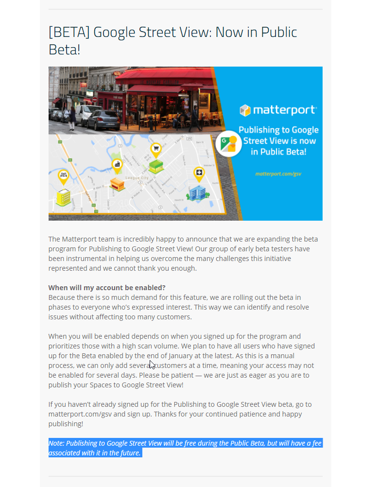
| This is Matterport... of course they are going to charge a fee for GSV Received this yesterday as part of the January 10th Newsletter:  |
||
| Post 6 • IP flag post | ||

Orange, California |
craigsauer private msg quote post Address this user | |
| Nice catch! | ||
| Post 7 • IP flag post | ||

Frisco, Texas |
Metroplex360 private msg quote post Address this user | |
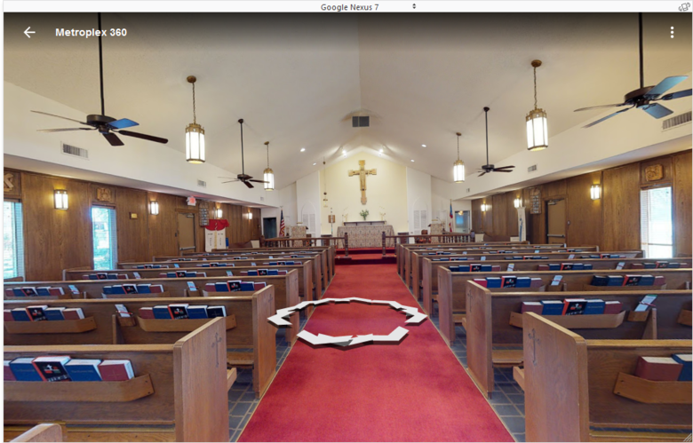
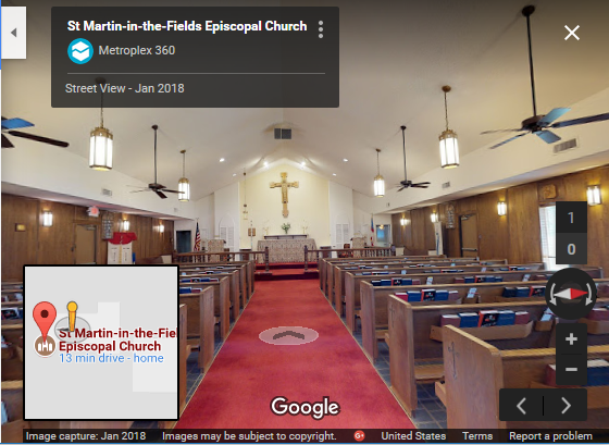
| The silver lining here is that it's FREE during BETA - and I imagine that the BETA will last quite a while. If I were driving Matterport's GSV program, there would be some objectives that I would want to reach in order to EXIT beta. #1) Inclusion of 360 Views -- using GPS (Pro-2 Exclusive), or manual connection. This is important in order to go outside. We know that the Matterport Pro camera's primary purpose is to create 3D spaces -- interiors. While we can 'go outside' in 3D scanning mode if conditions allow, the camera and its software is NOT optimized for this. 360 Views is a nice option, but does not offer connectivity as the panos are not positioned. For GSV, there are many reasons to want to use these 360 Views. One goal that many GSV Photographers TRY to reach is to have their tours connect to the street when possible. If panoramas are spaced 3-5ft from each other and reach a solid blue line (Street View from Auto), then the tour will be connected to the street. Additionally, some places are or contain outside areas. In order to be an end-to-end solution for GSV, it's imperative that we can capture these spaces too. The Pro-2 contains onboard GPS that can be used to align and connect these scenes -- however, it has not yet been utilized. #2) Ability to refine connections Matterport has innovated on the classic hotspot arrow navigation that has been used for years in panoramic tours by combining 3D Geometry with 2D Panoramas. The result is freedom of movement. Google Street View began with hotspot arrow navigation and has been moving towards freedom of movement. The resulting player is agnostic towards boundaries and when navigated via the mouse can result in viewers sailing from one side of a tour to the other. It's a very confusing system. Arrow navigation is still present on the mobile version. I've included an image below of a panorama on Google Street View that was placed using Matterport's GSV BETA. It includes far too many connections for mobile view.  'Pancake navigation' as I've heard Chris Petracco and Alin refer to it as, is the dominant navigation system and can be found on Google Maps or from the image carousel that launches from a place's infograph on Google Search. I've included the same scene as viewed via the pancake navigation system below:  Image #1 is unacceptable, Image #2 is perfectly acceptable. Matterport's generated connections for GSV is unacceptable for the player in image #1 -- but it's ideal for the player in image #2 - especially as Google moves away from #1 and towards #2 on all platforms. I believe that Matterport find themselves in a weird position here. Do they build out the tools to allow us to refine connections in order to optimize for a system that will be replaced some time in the future? Is this good when the future is a more free-moving system wherein multiple connections may enhance navigation? #3) Happy Customers Here's something even trickier. Funneling Matterport content into GSV produces inferior tours. The navigation is inferior, there's no dollhouse/floorplan view and with "See Inside" gone it's hard to explain to clients how average users will find these tours. The inability to set a start point is frustrating as it can be done in Workshop. Matterport are now having to manage expectations until Google fulfill enough of the expectations that it's contributers have had since the migration from Business View to Local Guides / Publish API. -- Therefore, in my humble opinion, GSV will remain free for quite a while until GSV matures, meets expectations, and provides a consistent experience that Matterport can allow its users to publish to. I want to emphasize ONE thing though -- Matterport HAS delivered an EXCELLENT platform for creating and publishing GSV content. There's little more beyond incorporation of 360 Views that Matterport SHOULD do to support the platform at the moment. They've nailed it. In the meantime, platforms like PanoSkin and GoThru are available and MSPs can import their tours, export 360 Views as 360 Snapshots and manually add these as well as edit and refine connections. Again, connection refinement should NOT be necessary, but it is due to fragmentation and that, I believe, should not still exist ... but it does ... because of internal fragmentation at Google. Imagine if Google has all of these things resolved by GSV Summit 2018? |
||
| Post 8 • IP flag post | ||
 WGAN Forum WGAN ForumFounder & WGAN-TV Podcast Host Atlanta, Georgia |
DanSmigrod private msg quote post Address this user | |
 Source: Matterport Support (2 March 2018) |
||
| Post 9 • IP flag post | ||
Pages:
1This topic is archived. Start new topic?


