Access 100+ 3rd Party Solutions to Help You Succeed Faster


|
Sdoughtie private msg quote post Address this user | |
| I just finished scanning a 33,000 SF building at 288 Scan Points with the Pro3 (Yeah, I missed my 199 goal). I have to provide ceiling plans and sprinkler locations for this particular client. More than half of this building did not have a gyp board or acoustical tile ceiling which makes it very difficult to get sprinkler head locations using the Matterpak .xyz file. The LOD is just not there to see sprinkler heads that are not in a ceiling. I usually go back and hand measure in this situation. The E57 file did a great job at showing these locations. This is my second time using an E57 file. The first time my computer was way under powered to handle it. I also use Autodesk Recap Pro and CloudCompare. To be honest, I prefer cloudcompare due to some of it's features; however, both applications have their advantages. One disadvantage of cloud compare was importing a 36GB E57 with 288 sweeps file fails miserably. I was able to open the same file in Recap without any issues. If you are looking for a way to get a pointcloud out of Recap to use in Cloudcompare: I unified at 5mm resolution the pointcloud and exported it as another E57 file. It opens in cloudcompare with not issue. The finial cloud was 860M points. |
||
| Post 1 • IP flag post | ||
|
|
Kharvester private msg quote post Address this user | |
| This is very interesting to me as I have been wondering about the usefulness of the pro3 point cloud (E57) for use in construction/as-built/digital twin applications. Do you feel that the E57 from matterport is close enough for modelling from? Also what is the difference between the E57 & XYZ? | ||
| Post 2 • IP flag post | ||
 WGAN WGAN Basic Member Boston |
Noddy private msg quote post Address this user | |
| @Sdoughtie, thanks for that info. Good to know about file size behavior in Cloud compare vs Recap Pro Could you share what computer specs you are using now? |
||
| Post 3 • IP flag post | ||
|
|
Sdoughtie private msg quote post Address this user | |
| @Noddy Processor 12th Gen Intel(R) Core(TM) i9-12900H 2.50 GHz Installed RAM 32.0 GB (31.7 GB usable) System type 64-bit operating system, x64-based processor Pen and touch No pen or touch input is available for this display Manufacturer Alienware GPU NVIDIA RTX 3070 Ti |
||
| Post 4 • IP flag post | ||
|
|
Sdoughtie private msg quote post Address this user | |
| @Kharvester I usually model from the xyz file, however, I take physical dimensions onsite in case there are issues; I did the same on this job, but not the sprinkler heads. Some of the problems that I run into with modeling from a pointcloud is that buildings are not square. I find there is 'creep' when it comes to aligning a BIM to a real-world building. An example would be that an exterior wall may differ by 2" over 150'; Let's say there is an office at the far end. Placing one wall of the office in alignment with the pointcloud will result in the office being 2" too short or long. Not really an issue over 150' but that really matters if the office is 5' wide. Seems like the E57 is very detail, I can see and measure to the sprinkler pipe, they do not even show up in the xyz file. Additionally, I have not updated the pro 3 to use the increased LOD. Frankly, I am afraid that I will get a bricked camera in the middle of all these projects. I will probably end up purchasing another Pro 3 before I update it. |
||
| Post 5 • IP flag post | ||
|
|
Vanaman06 private msg quote post Address this user | |
| I haven’t used the increased LOD but I have had the update since it came out and have not had any issues at all. High LOD takes about 2 minutes per scan so significantly more time. The Update didn’t improve anything else as far as I can tell so if you’re not using the increased LOD it’s probably not necessary. |
||
| Post 6 • IP flag post | ||
|
|
Sdoughtie private msg quote post Address this user | |
| @Vanaman06 awesome! thanks for letting me know! | ||
| Post 7 • IP flag post | ||
|
|
Sdoughtie private msg quote post Address this user | |
| @Vanaman06 I updated the pro3 with no issues. Thanks. | ||
| Post 8 • IP flag post | ||

|
DigitalReplica3D private msg quote post Address this user | |
| Regarding high LOD. I'm currently scanning an ADU as it is being built. I scanned the unit after plumbing and heating was installed. I scanned the unit again, after insulation was in place. When it came to drywall. The installers covered the entire garage ceiling with drywall. The drywall covered all the electrical wiring for 16 recessed lights. They also covered a can light upstairs and access to the attic area. To find the appropriate locations. I went back to the "Plumbing & Electrical" space and compared it to the "Insulation" space. The later, I scanned using a medium density setting vs standard density. I have not tried the highest density setting. I find the measurement feature while editing the space, worked much better with the medium density vs standard density scan. I was able to pinpoint the crosshairs on my target quicker and more accurately. The measurement crosshairs with the standard density scanned space bounced around and sometimes a location was impossible to target. I know for accuracy. The XYZ, E57 and BIM deliver much higher tolerances vs MP's processed space. I still wonder why MP's space only measures in one inch increments. You'd think perhaps 1/4 inch increments would be possible @Sdoughtie I appreciate your input. Curious in the future what you thoughts are regarding BIM and high density scanning. Best, Charlie 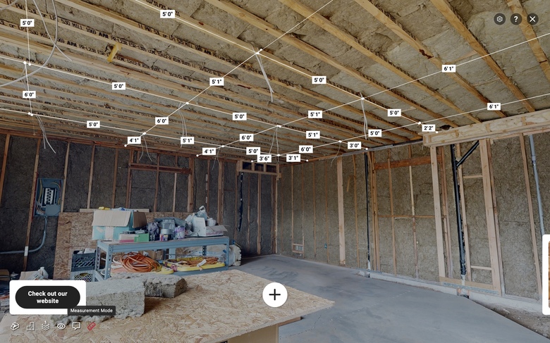 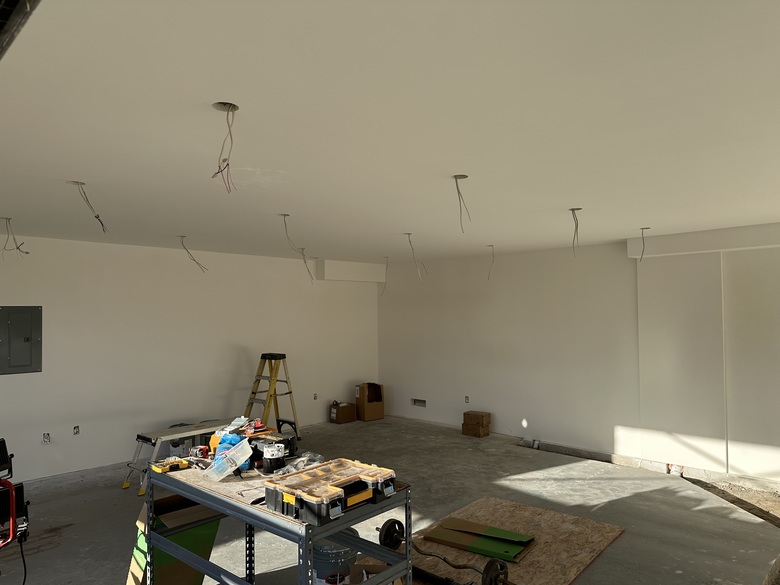 |
||
| Post 9 • IP flag post | ||
|
|
Sdoughtie private msg quote post Address this user | |
| @DigitalReplica3D great job! | ||
| Post 10 • IP flag post | ||
|
|
Sdoughtie private msg quote post Address this user | |
| Just started using this. LASTOOLS offers some great command line tools for working with pointclouds. Github LASTOOLS And, I didn't realize that I had cloudcompare set to us the integrated gpu instead of the actual GPU. Wow, what a difference! |
||
| Post 11 • IP flag post | ||
|
|
Sdoughtie private msg quote post Address this user | |
| Note, many of the LasTools are not free. They require a license. There are quite a few useful ones that are free. Without license the non-free tools will distort your pointclouds. Below is a list the tools that can be freely used. Two in particular would be e572las and las2las for converting an e57 file and thinning the file to a manageable size. This will thin your cloud to 1/8" resolution: las2las64 -i cloud.las -o cloud-thinned8.las -thin_with_grid 0.003 Open source tools laszip - compresses LAS files to LAZ in high speed without information loss las2las - filters, transforms, subsamples, clips, thins, ... las2txt - turns LAS/LAZ into human-readable and easy-to-parse text txt2las - converts LiDAR from standard ASCII to LAS/LAZ lascopcindex - creates a COPC *.laz file for a given set of *.las or *.laz files lasdiff - compares LIDAR data of two LAS/LAZ/ASCII files and reports whether they are identical or whether they are different lasinfo - prints out an overview of the contents of a LAS/LAZ file lasmerge - can merge several LAS/LAZ files into one lasprecision - reads LIDAR data in the LAS format and computes statistics about precision "advertised" in the header Free tools lasview - visualizes the contents of a LAS/LAZ file and can also compute a TIN lasvalidate - determine if LAS files are conform to the ASPRS LAS specifications demzip - compresses and uncompresses raster data to RasterLAZ format e572las -extracts the points from the E57 format and stores them as LAS/LAZ files |
||
| Post 12 • IP flag post | ||
|
|
Sdoughtie private msg quote post Address this user | |
| These are the sprinkler pendants... This is in height ramp color to be able to see the pendants more clearly. Note: all dimensions in Cloudcompare are at the pointcloud resolution, in this case Meters. 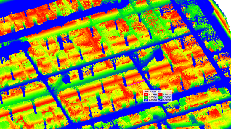 |
||
| Post 13 • IP flag post | ||
|
|
Sdoughtie private msg quote post Address this user | |
| Another issue is, the e57 file has all of the photospheres inside of it. It is possible to extract those and use them elsewhere. I would just purchase the e57 file instead of the matterpak except the e57 seems to have a lot of noise and is not as sharp as the .xyz file. I suspect that the .xyz file is generated from the model rather than the scan data. Anyone know how to get the e57 as sharp as the .xyz file? |
||
| Post 14 • IP flag post | ||
|
|
Sdoughtie private msg quote post Address this user | |
| Continuing the saga, instead of starting a new thread, I scanned a space with mixed standard and medium density. The online model and .xyz file was notably more dense…. my main interest is framing and sprinkler… (this is the online model)(yes, thats a lamborgini)  |
||
| Post 15 • IP flag post | ||

|
AnjumDesign private msg quote post Address this user | |
| I also use point cloud to create floorplans and I use cloud compare only. One of the main issue of using Matterport is the cost of buying poinctcloue each time for £48. I have BLK360 G1 but this very slow and its only works with Leica software to register all scans which is again extra expense for using their software. New BLK360 G2 now allows to register scans on the device and provides free export option for E57 file. I am now looking to buy BLK360 G2 to use above workflow What is your view on above? |
||
| Post 16 • IP flag post | ||
|
|
Sdoughtie private msg quote post Address this user | |
| Thanks!!! That's good to know! | ||
| Post 17 • IP flag post | ||
 WGAN Forum WGAN ForumFounder & WGAN-TV Podcast Host Atlanta, Georgia |
DanSmigrod private msg quote post Address this user | |
Quote:Originally Posted by AnjumDesign @AnjumDesign Do you need the BLK360 G2 to be compatible to Matterport? The BLK360 G2 is currently not supported. Only the BLK360 G1 is currently supported," according to this Matterport Support page last updated: 10 October 2023. Best, Dan |
||
| Post 18 • IP flag post | ||
|
WGAN Basic Member Boston |
Noddy private msg quote post Address this user | |
| To all, Re: the accuracy with Pro3 scans & Point clouds, I have 2 questions that Matterport apparently can't or won't answer for me, acn you guys help? 1) What is the accuacy / measurment tolerance for the Pro3 assuming a space is fully scanned? i.e.if 2 walls were exactly 100 ft apart in reality, and I scanned the room with Pro3 and measured the point cloud distance between walls at same point, what would the +/- tolerance be on that measurement? I also do high res. object scanning, and every scanner I own has a spec for accuracy / tolerance, but Matterport just won't give me a number for the Pro3, anyone? 2) I am getting inquiries for scans from folks who want to do BIM models, or outdoor site / land scans, and I just don't know what to claim for LOD, can you guys tell me is Pro3 / e57 point cloud considered LOD 100, or 200? I'd hate to have somebody try to build a model based on my scan files and then have a problem due to measurement error.. so I want to be real with expectations. When would / should someone hire a full-on surveying company (with I assume sub-millimeter accuracy over long distance) vs hiring a PRO3 scan / site survey / as built survey? Thanks! |
||
| Post 19 • IP flag post | ||
|
|
Sdoughtie private msg quote post Address this user | |
| 1. I regularly take spot dimensions in case there is a problem and over a 100 ft it’s usually a 1/4” accurate. However, it depends on where I took the spot dimension due to sheathing bulges and if I had the laser perpendicular to the target. I don’t think there is anyway of knowing for sure by this method. 2. LOD is a weird subject for me. You have BIM LOD and Point cloud LOD. I can’t find anything that says a standard point cloud LOD specs. Which I would assume it would be LOD 200. The E57 files are really dense, but I doubt you are going to get fraction millimeter accuracy. MP has some sample point clouds on their site you can download for each camera. https://support.matterport.com/s/article/Overview-of-Matterport-E57-File?language=en_US |
||
| Post 20 • IP flag post | ||

|
Aerial_Perspective private msg quote post Address this user | |
Quote:Originally Posted by Sdoughtie Nice thread! Did you figure out a way to get a sharp e57 file in the end? |
||
| Post 21 • IP flag post | ||