


Benchmarking Floor Plans: Matterport, Zillow, CubiCasa and Urbanimmersive19262
Pages:
1
 WGAN Forum WGAN ForumFounder & WGAN-TV Podcast Host Atlanta, Georgia |
DanSmigrod private msg quote post Address this user | |
 Image courtesy of Urbanimmersive Benchmarking Floor Plans: A Comparative Study of Matterport (Pro2 Camera, iPhone, Ricoh Theta Z1), Zillow, CubiCasa (with and without LiDAR), Giraffe360, Immoviewer, EyeSpy360 and Urbanimmersive 3D Video Fusion [The following is reprinted with the permission of Urbanimmersive.] 21 November 2023 The real estate industry is witnessing a surging demand for integrated floor plans. Amidst this growth, various floor plan providers are vying for a larger slice of the market. Recognizing the need to evaluate the effectiveness of different floor plan technologies, FloorPlanOnline®, a renowned expert in the floor plan sector since 2004, embarked on a benchmarking study. This study assessed the accuracy and time efficiency of various technologies. Urbanimmersive, a key player in this domain, has secured the rights to publish and provide insights on these findings. Among the evaluated technologies is Urbanimmersive's new 3D Video Fusion. So... -- While acknowledging our inherent bias, we aim to offer an informed perspective, leveraging our industry experience to shed light on our technology's notable performance in the study.-- Let's delve into the findings and implications. Study Overview: Study Overview: FloorPlanOnline®'s evaluation focused on major contenders in the 3D tour technology arena, including Matterport, Zillow, Urbanimmersive 3D Video Fusion, and Cubicasa. Other players, such as EyeSpy360, Giraffe360, and Immoviewer, were also tested. The assessment primarily revolved around the accuracy of these technologies in capturing Gross Living Area (GLA) measurements. The GLA measure was selected for the following reasons: 1. The presence of open spaces in floor plans, which often blur the boundaries between different zones is not alone a good indication of precision; 2. Differences in how providers apply measurement rules of room. This includes considerations like the treatment of closets in room dimensions and the approach to measuring rooms at 45-degree angles. It is agreed that regardless of how room dimensions are assessed and presented by providers, these should not affect the final calculation of the Gross Living Area (GLA). Additionally, the study evaluated the time efficiency of each technology in scanning a space. Urbanimmersive's comments further extends to considerations like equipment, cost, delivery time, and the quality of output. While FloorPlanOnline®'s study presupposes adherence to the best practices and guidelines established by each technology provider, it's important to note a caveat. Our observations suggest that, although it didn't markedly affect the outcomes, certain specific rules for creating precise floor plans using 3D Video Fusion weren't always followed consistently. We can only surmise that similar deviations might occur with other providers. Therefore, the results of the FloorplanOnline® study could potentially differ from what those providers might achieve themselves. Each technology provider was benchmarked against a professional hand laser measure survey. The house layout used for the test presented multiple small challenges, including curved stairs, the step down to the living room floor, and the diagonal shape of the office.  Image courtesy of Urbanimmersive Key Findings Matterport The Matterport Pro2 demonstrated exceptional accuracy, with its measurements perfectly matching those from the hand laser measure survey and showing no deviation. The floor plan was error-free, with no omissions. The dollhouse view provided a clear representation of the floor plan's accuracy, especially when overlaid with the bird's-eye view. All industry-standard rules were meticulously adhered to in the process. However, the Pro2 Matterport camera's perfect score comes with a cost. Matterport required the most time to scan the test area among all contenders, taking 50 minutes. Additionally, the Matterport system is distinguished by its significant hardware investment cost. It is also the most cumbersome in terms of transportation and demands the highest monthly subscription fees when compared to the other technologies evaluated. Matterport provides various scanning options. When utilizing a 360 camera like the Ricoh Theta Z1, the study found a notable increase in deviation, averaging 1.47%. However, this method significantly reduces scanning time, averaging only 17 minutes across the two tests performed. The Matterport iPhone scanning app, used in conjunction with the Axis, displayed remarkable results, achieving a mere 0.28% deviation. However, it required one of the longest scanning time (30 minutes) among all the contenders included in the study. --- Zillow Zillow's floor plan exhibited the highest deviation in FloorPlanOnline® tests, reaching 9.90% for a scanning time of 20 minutes. Although the floor plan was delivered with diagonal room dimensions, which do not affect the Gross Living Area (GLA) calculations, this approach deviates from floor plan industry standards. Zillow’s floor plans are quite basic, omitting furniture layouts and door opening directions, and thus resemble a simple wireframe of the house more than a comprehensive floor plan. They belong to the entry-level product category in this market segment and serve as a sufficient option for presenting a visual sketch of a house's layout. The fact that Zillow offers these floor plans for free could be a contributing factor to their limited details. Zillow offers a 360 tour alongside its floor plan, which falls into the category of an entry-level product as well. Their 3D Tours offer a less immersive experience, one that seems somewhat outdated, particularly when compared to the sophisticated and captivating solutions offered by companies like Matterport and Urbanimmersive. CubiCasa Cubicasa is a leading brand in the floor plan industry. The team at FloorPlanOnline® conducted multiple scans using Cubicasa technology and analyzed the variations in deviations between each scan. The goal was to establish an average deviation between the non-LiDAR and LiDAR usage. They found that the LiDAR feature had an average deviation of 0.56%, while the non-LiDAR application had a significantly higher deviation of 2.97%. FloorPlanOnline® tests revealed a notable difference in the standard deviation when not using the LiDAR feature. We hypothesize that variations in the height at which the scanner was held during different scans might have affected the scale, particularly for multi-level floors which was the case of the space scanned for the study. The LiDAR feature appeared to capture these details more accurately. Our takeaway is that if you opt to use Cubicasa, utilizing the LiDAR feature is advisable. For high-volume photography businesses, we suggest using a dedicated device specifically for scanning. This approach helps prevent running out of memory, a concern given the extensive data captured by the LiDAR function. With that said, FloorPlanOnline® has identified numerous angle inaccuracies in all floor plans delievred by Cubicasa, regardless of whether they were created with or without LiDAR technology. These flaws become evident when importing the layouts into advanced floor plan drawing software, such as the one developed by FloorPlanOnline®. These incorrect angles pose challenges when integrating with third-party software, as they require correction for effective use. Additionally, our internal tests of Cubicasa, conducted independently of the FloorPlanOnline® study at Urbanimmersive’s office, revealed also noticeable layout inaccuracies. These included incorrectly placed doors and some that did not indicate the direction of opening, as shown in the illustration below. 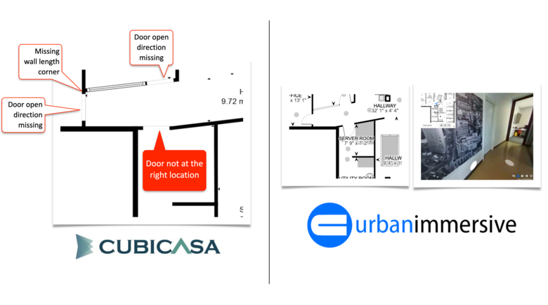 Image courtesy of Urbanimmersive The absence of visual content references accompanying the delivered Cubicasa floor plans is a significant drawback. This hinder anyone unfamiliar with the space from detecting such layout errors. In our opinion, this is a crucial deficiency that sets Cubicasa apart from its competitors, who typically provide a 3D visual representation alongside the floor plan. Cubicasa prides itself on offering the fastest scanning method in the market, with an average scanning time of 5.52 minutes. This makes it the second-fastest option in the FloorPlanOnline® study, following Urbanimmersive. It's important to note that these tests were carried out by seasoned Cubicasa user, who has completed numerous scans. In contrast, with Urbanimmersive, this was the initial trial run of the 3D Video Fusion technology. --- Immoviewer According to FloorPlanOnline®, Immoviewer's floor plan showed a deviation of 2.06% with a scanning time of 20 minutes. This positions Immoviewer slightly ahead of Cubicasa's non-LiDAR scan, yet it falls short of the accuracy achieved by Cubicasa's LiDAR scan and other rapid technologies like Urbanimmersive, which delivers much better results with just a 5-minute scan. Furthermore, the floor plan drawings from Immoviewer lacked precision in depicting curved stair walls, as can be seen in the image below. 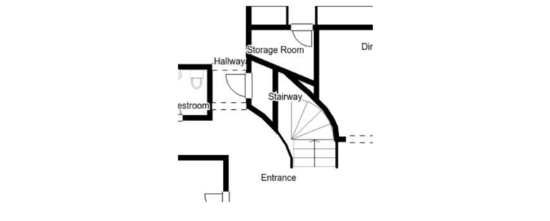 Image courtesy of Urbanimmersive --- EyeSpy360 Examining the results from the FloorPlanOnline® study, we just can question to see that EyeSpy360 had the highest deviation among all contenders at 10.57%. This raises questions about potential issues during the scanning or drawing process. Upon reviewing the quality of the floor plan, we observed numerous graphic defects which, in our view, seem to stem from issues with SVG line coding. Some lines are thicker than others; some are not rectangular. We also noticed problems with the drawing of curved stairs. The plan also shows a door between the foyer and the living room, which does not represent reality, as you can see from the layout of the test house shown at the beginning of the article. Describing the quality of the floor plan in words is challenging, so we have decided to present it below, allowing you to form your own opinion. Note: We believe that the creation of floor plans is not exclusive to EyeSpy360 and can also be accomplished by photographers using their software. While this might account for the deviation of 10%+ observed, it does not excuse the graphic issues evident in the examples shown below. 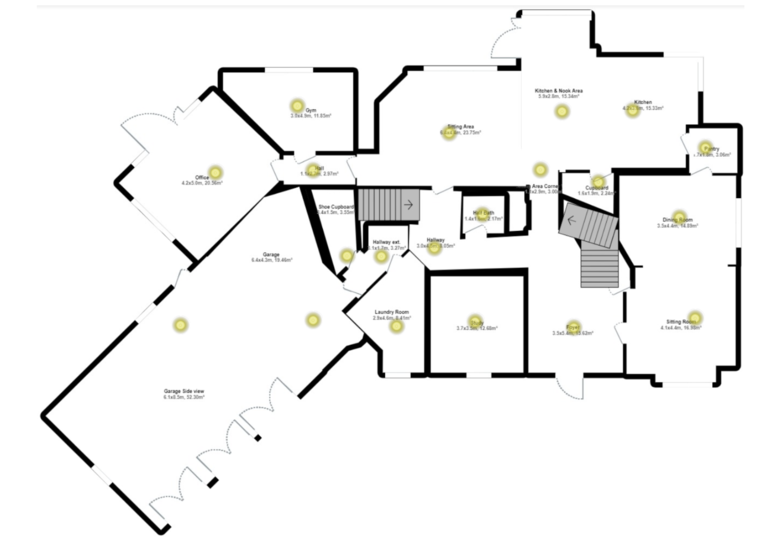 Image courtesy of Urbanimmersive --- Urbanimmersive's New 3D Video Fusion (3D VF) Floor Plan Urbanimmersive's New 3D Video Fusion (3D VF) Floor Plan The floor plan generated from Urbanimmersive’s 3D Video Fusion technology showed an impressive deviation of only 0.28%, ranking among the best in all the tests conducted. Urbanimmersive's 3D Video Fusion technology utilizes 360-degree camera video recordings to generate both floor plans and 3D tours. The only other company in the test that uses video recording is Cubicasa; however, their approach involves 2D frame videos, not the 360-degree format employed by Urbanimmersive FloorPlanOnline® conducted a scanning test using Urbanimmersive's new 3D Video Fusion technology, with the option to include 3D digital twins in the deliverable. This scanning process demanded extra time to ensure the creation of a 3D tour free from any human presence. This was accomplished by the photographer setting up the tripod and then moving out of view, followed by our advanced visual content recognition processes extracting 360 views without the photographer in it. The test area was scanned in under five minutes. Note, if the objective had been limited to producing only a floor plan, the process could have concluded in less than three minutes, ranking Urbanimmersive 3D VF as the quickest scanning method currently available. Here is the final floor plan generated by Urbanimmersive from a 5-minute scan. Note: The garage was not scanned, which is why it is missing from the plan. 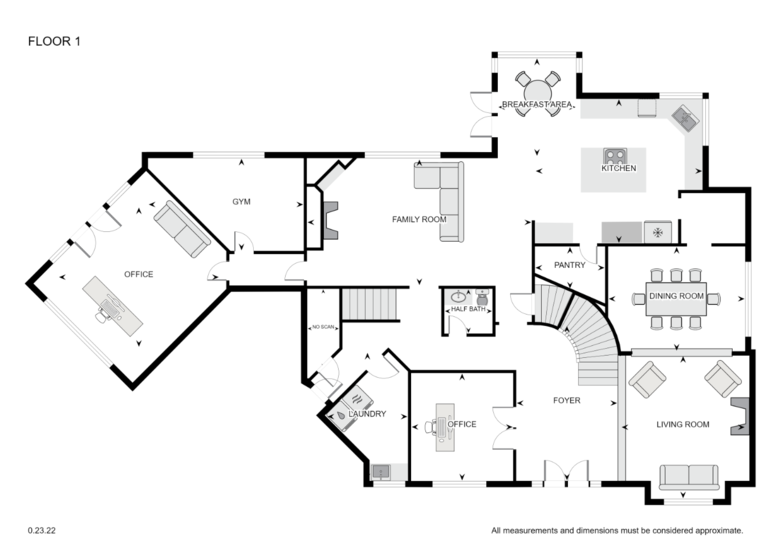 Image courtesy of Urbanimmersive This high level of precision is attributed not just to the scanning method, which utilizes thousands of 360 images from the video recording, but also to the advanced post-production techniques developed and fine-tuned over the last 10 years by Urbanimmersive. These techniques involve a dual-pairing system that aligns 360-degree image anchors in a continuously single line. Benefits of Urbanimmersive's Floor Plan Post-Production Technology Essentially, Urbanimmersive's floor plans are uniquely crafted from a single, continuous line, in contrast to other methods like Zillow (see paragraph 3.3.3 of their paper here), that assemble each room's layout piecemeal, much like putting together a puzzle. Creating a floor plan from a single continous line can only be accomplished by systematically anchoring each panoramic view to the next, which ensures consistent calibration and alignment of the visual data, walls, doors, windows and objects. In scenarios where pairing visual anchors between two panoramas is impractical, or in situations like the space behind a closet wall as demonstrated in the above video, Urbanimmersive utilizes virtual 'white rulers' for auto-correction. 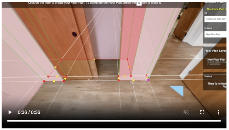 Image courtesy of Urbanimmersive This method ensures that each wall is accurately represented and cross-verified in the final layout. If the end of the continuous line does not align with its starting point, suggesting a potential inaccuracy, a manual review is triggered. Urbanimmersive's cutting-edge single-line floor plan technique significantly boosts the 3D Video Fusion's ability to create accurate floor plans for very large buildings. The image displayed above illustrates this capability, depicting one floor of a school that covers more than 250,000 square feet. This proficiency in handling large building floor plans distinctly sets Urbanimmersive apart from all other competitors in the study. 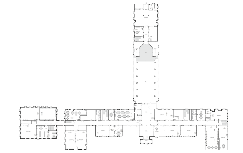 Image courtesy of Urbanimmersive Employing 360-degree imagery, as opposed to a singular 2D video stream, enables the utilization of numerous visual content descriptor anchors from a comprehensive range of angles. These anchors play a vital role in accurately mapping and aligning walls and objects within a given space, particulary in large environments. They markedly enhance the precision of the alignment process, thereby improving the overall quality and dependability of the resultant floor plan. This approach is comparable to sophisticated spatial recognition methods. In simpler terms, 360-degree visual content offers a data-rich alternative compared to an iPhone video scan app. The Tripod Effect vs Handheld Urbanimmersive's use of a 360 camera on a tripod for the video recording, compared to Cubicasa's handheld iPhone approach, facilitates easier calibration and ensures consistency across floor levels. The height at which the camera is positioned affects the perceived scale of objects on the floor, with variations in height posing calibration challenges, particularly when changing floors or in larger environements. We beleive this could explain the higher deviation obtained with Cubicasa with the non-LiDAR version. Using a tripod not only increase the precision of the scan but also enables the creation of a seamless 3D digital twin user experience. This is a key benefit of Urbanimmersive's Video Fusion technology. 3D VF has the ability to consistently produce 3D digital twins, even from scans as brief as 3 minutes. This feature is invaluable, serving not just for marketing purposes but also for cross-verifying the accuracy of floor plans. It's particularly advantageous for validating the precision of plans created for third parties who haven't physically visited the site, ensuring reliability and accuracy in their representations. Is Laser Scan Better? Laser technology is known for its high precision, regardless of whether the hardware is old or recent. However, the challenge lies not in the capture of highly precise point cloud data, but rather in the drawing methods employed during post-production. To elucidate this point: laser scans create a point cloud, from which lines are either automatically or manually drawn, typically at the average center of the point clusters. However, as seen in the image below (from our own laser scanning usage, not the study), these lines can sometimes be inaccurately placed or fail to precisely follow the contours of all wall corners. Such minor inaccuracies can accumulate, leading to greater deviations in the post-production drawings. This was evident in the FloorPlanOnline® study, where a laser scanning technology resulted in a deviation higher than some non-laser alternatives. 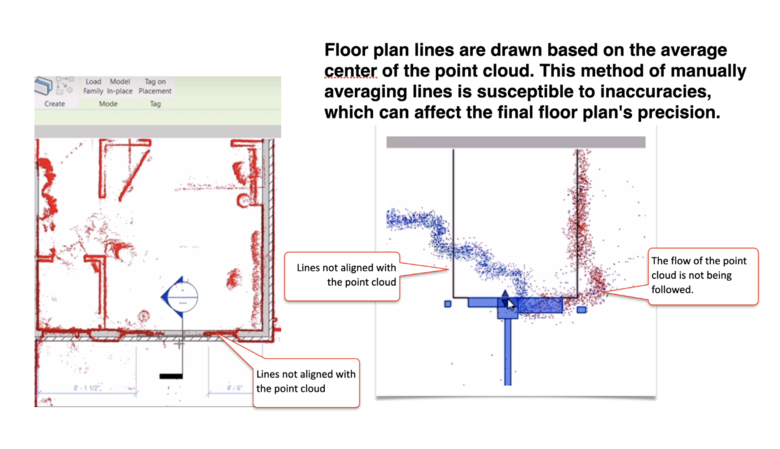 Image courtesy of Urbanimmersive Another important factor to consider is that laser scanning hardware typically comes with a higher cost. Given the findings of the FloorPlanOnline® study and the post-production drawing challenges we have outlined, photographers should carefully evaluate the real necessity of laser scanning in relation to their specific needs Giraffe360 The Giraffe360 utilizes LiDAR technology in its scanning hardware. The results obtained by FloorPlanOnline® are outstanding, surpassing even Giraffe360's own claims on their corporate website. The floor plan deviation was a mere 0.28%, on par with the Matterport iPhone App with Axis and Urbanimmersive 3D VF. Unfortunately, Giraffe360's impressive accuracy comes with longer scanning times, similar to the Matterport Pro2, 50 minutes. Although their pricing model is quite innovative, it still represents a higher cost compared to non-LiDAR hardware. As highlighted in the previous paragraph, this serves as solid evidence that while laser scanning hardware is highly precise, it can produce results comparable to certain non-LiDAR technologies. --- Acceptable Deviation Accuracy Understanding that variations are common in different scans using the same technology is essential. Even measurements taken manually with a laser can show slight discrepancies from one scan to another. In our internal tests, we found that measurements taken by different individuals using hand lasers can have a deviation of up to 1.5%. In its survey, FloorPlanOnline® hired a hand laser service from Home Depot and observed a 2% deviation compared to the measurements taken by FloorPlanOnline®'s professional hand laser. It tells it all! This variation often stems from factors such as the exact points where measurements were taken in the rooms, whether the laser was positioned squarely against the walls, and even if the walls themselves were perfectly square. Observing how frequently home builders take measurements, double-check them, and so on, illustrates the inherent 'noise' in these potential deviations. Moreover, anyone who has seen the process of measuring for a granite countertop will appreciate that achieving highly precise measurements requires significant expertise... It’s critical to acknowledge that the accuracy of scanning methods is also significantly dependent on the techniques used during the scanning process. Matterport stands out in this regard (during the test with the Pro2), with its App consistently guaranteeing precise scan practices. However, this rigorous approach can be challenging for high-volume businesses due to the increased time required on-site. Considering that Matterport's floor plans, like those of its competitors, come with a disclaimer of being approximate, one must question the advantage of using such detailed scans. For all other competitors, adhering to best scanning practices is key to ensuring optimal results. Critical factors for improved accuracy encompass properly positioning the scanning equipment, positioning it close to walls, maintaining sufficient lighting, and meticulously maneuvering through spaces during the scan. These steps are essential to achieving the highest level of precision in the final outcomes. In the study conducted by FloorPlanOnline®, all competitors have indicated that the measurements and layouts provided in their floor plans should be considered as approximations only. Essentially, this means that none of the providers are assuming responsibility for the precision of their floor plans, and therefore, agents should not be using these dimensions and layouts for populating their listing requirements. Taking this into account, it is generally accepted that an acceptable deviation for a floor plan scan, when compared to hand-taken measurements, is anything around 1.5%. This degree of precision is deemed sufficient for practical uses of floor plans, such as gaining a comprehensive understanding of a house's layout, planning furniture placement, calculating the quantity of paint needed, and similar applications. Summary We have compiled a summary of the FloorPlanOnline® survey, ranking providers from the lowest to the highest deviation, and the scanning time required for each. We recognize that, as mentioned at the beginning, these results could vary based on the photographer's experience. However, we believe the findings confirm the overall reliability and effectiveness of the technologies evaluated. They provide a valuable benchmark for understanding the performance capabilities of each system in real-world scenarios. 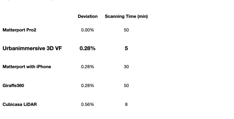 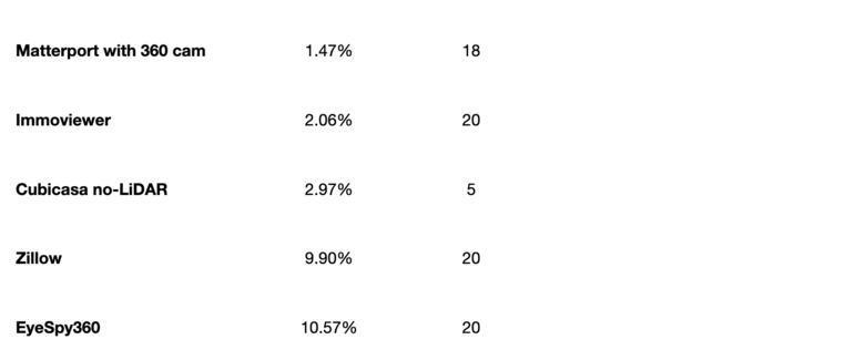 Image courtesy of Urbanimmersive And The Biggest Winner Is... In assessing the creation of floor plans, a critical balance exists between speed, cost, deliverables, and accuracy. The specific requirements of a use case may influence which factor is prioritized. However, for homeowners seeking to use their floor plans for more than just marketing visuals, accuracy often becomes the key element. Urbanimmersive's 3D Video Fusion technology stands out particularly in this context. It not only produces highly accurate floor plans but also excels in terms of speed and cost efficiency. Additionally, it offers a unique value proposition with its 360 video fusion content. This combination makes Urbanimmersive's solution exceptionally well-suited for those who value a high degree of proficiency in each of these critical aspects, thereby marking Urbanimmersive as the most advantageous offering identified in the study. -------- Disclaimer: The methods, findings, and conclusions presented in this blog are based on the FloorPlanOnline® survey and are intended for informational purposes only. They reflect our observations and interpretations of the data collected. Results may vary depending on various factors, including but not limited to the skill and experience of the photographer, specific environmental conditions, and the particularities of each scanning technology. While we have strived for accuracy, we do not guarantee that our analysis is free from errors or omissions. All trademarks mentioned in this blog, including but not limited to FloorPlanOnline®, Matterport, Urbanimmersive, Cubicasa, and Zillow, are the property of their respective owners and are used here for identification purposes only. Their use does not imply endorsement by or affiliation with the respective trademark owners. --- Source: Urbanimmersive Blog Post on 21 November 2023. Reprinted by Permission. |
||
| Post 1 • IP flag post | ||
|
WGAN Forum Founder & WGAN-TV Podcast Host Atlanta, Georgia |
DanSmigrod private msg quote post Address this user | |
WGAN-TV | How to Scan with Urbanimmersive Ultra-Fast 3D Digital Twins App and 3D Video Fusion + Floor Plans | Guests: Urbanimmersive Inc. President and CEO Ghislain Lemire and Urbanimmersive Inc. Executive Vice-President François-Hugues Liberge | Episode: 205 | Thursday, 26 October 2023 | @fhliberge www.WGAN.info/Urbanimmersive Hi All, WGAN Forum Members receive three (3) free Urbanimmersive 3D Video Fusion Tours with Floor Plans. Set up a Free Urbanimmersive Account: www.WGAN.info/Urbanimmrsive | 3 Free: Coupon Code: WGAN Best, Dan |
||
| Post 2 • IP flag post | ||
 MP2FP MP2FPFloor Plans Bangkok THA |
mp2fp private msg quote post Address this user | |
Thank you Dan for a good article that shows there is several dedicated tech solutions to register input to produce basic plan presentations! If any of you need an independent provider that can deliver all types of 2D, 3D floorplans or BIM models, the next day, and with no bindings to particular HW or SW, consider as well to check out the many year WGAN service provider MP2FP. MP2FP can handle any input from any provider or file formats and as well produce the accuracy you want. If you need advisory of the best and most affordable scan apps at the time, and as well how you can add more accuracy without sell your shirt (or car) we can help you with free and independent advise depending on your needs and wishes. As one example right now an easy and fast, flexible and cost efficient AI/AR or pointcloud scan app we recommend for ipads and iphones with lidar is the Polycam app. They have a free version where you can export glb or RAW data 3D files (AR scan and/or pointcloud) and as well an option is a cheap subscription that can export almost any 2D or 3D formats. Any of these formats, together with eventually any extra input to make your project stands out from the crowd, can be uploaded to the MP2FP portal and you will have the wished dream floorplan or BIM model back the next day. Contact us for an order or a free advisory based on your needs. Send any file from Polycam or any other app (or a mix with manual measures to calibrate for most accuracy independent of scan method) to us if you need high quality delivered in short time the next morning while we work when you sleep: + 2D or 3D floorplans + Fully or partly furnished as wished + All types of measures + Any standard or custom styles + No limits in size (ask for special offer if more than 10k sqf) + Upload in your evening you will have it ready before you wake up next day + 50% discount if you send us a vector file or GLB AR scan file from Polycam app + Your or your client logo and layout included (we never demand our logo or reference on any of your orders) + Free numbers of amendments + No in advance subscription or complex point based fees + Pay as you go or end of month payment with summary report for regular partners + Extra discounts for regular clients + Additional services like BIM, CAD, Photo editing, Virtual home staging and high end 3D CGI presentations + Free advisory of at the time most sufficient best HW or SW for data registration in field based on your particular needs + NB! We are an independent provider owned by the employees and we not sell or share any info about our clients to 3rd parties as we are very passionate about the work and want to keep the good and long lasting and forward development based relation with our partners and clients!  |
||
| Post 3 • IP flag post | ||
Pages:
1This topic is archived. Start new topic?