


Google Street View about blue line point to point linking?19232
Pages:
1|
|
ron0987 private msg quote post Address this user | |
| I completed an exterior scan of a business and the client was happy with the results and asked to upload it to Google maps. I have completed Google street view projects before and there was never a problem to get the blue lines to appear. In some cases it took several days to a week but they would appear. I uploaded this model a few weeks ago and still no blue lines. I know they switched from the old Google street view app and cannot find clear link to login and manually add the blue lines. Any and all help would be appreciated. Thanks in advance. Ron |
||
| Post 1 • IP flag post | ||
 WGAN Fan WGAN FanClub Member Queensland, Australia |
Wingman private msg quote post Address this user | |
| Ron, blue line capture is not what you are doing with Matterport. It is called that way because it is represented as a blue line on maps and it actually shows a google car street view capture for streets/roads. It does not mean you cannot capture something for a business or public path but usually it is done with a 360 degree video mode. What you have done with Matterport is what is used to be called business inside view and it is represented as circles or donuts. It is not supposed to turn into a blue line. As long as all links between each scan point published on maps are working you have done it right. In theory 2-4 business days is ok these days to get a business inside view tour to become fully functional. Here is one I published this month. if you go back to maps and click on Google yellow pegman you will see each spot from their tour shown as a donut. And this tour also supports levels as this business is on the first floor. I have done it from a carpark on the ground just to show customers how to get to their office. |
||
| Post 2 • IP flag post | ||
|
WGAN Fan Club Member Queensland, Australia |
Wingman private msg quote post Address this user | |
| BTW, I do not use a tour on Google Maps after publishing through Matterport. They create too many links between scan points, even sending users through walls. I download a tour after publishing from Matterport into Pano2VR Pro and delete it from Google Maps either through Matterport or Pano2VR. They I remove all excessive links created by Matterport, add a customer logo at Nadir and upload it back as a final version using Pano2VR publisher. | ||
| Post 3 • IP flag post | ||
|
|
ron0987 private msg quote post Address this user | |
| @Wingman I appreciate your input as advice. I just remember when I first used Google street view on a desk top you could connect view points even in businesses with blue line. Google moved to app impute and at first you could connect each view point. I have used Pano2vr and liked it too. I am also familiar with the blue line video mode on the street, just does not work in businesses. The more I look I see no blue lines in businesses in my area. Most business owners are like me they remember the blue lines in businesses. | ||
| Post 4 • IP flag post | ||
|
WGAN Fan Club Member Queensland, Australia |
Wingman private msg quote post Address this user | |
| I am still not sure how businesses around you got any blue lines attached to them. The way any blue line is published does not allow to specify any place id. It is just published as street view and belongs to no place. So a blue line can run through some business on Google Maps(I have an example with a golf course for it) but it does not belong to it. There is a walkaround that I've discovered by accident. It lets creating a blue line for a specific place. However it is time consuming and still will fail for publishing 360 photos that have been captured indoor(no location data in EXIF). Plus if you cannot make it belonging to a place/business such a place won't get any views count for a place/business ranking. It will show a place/business for sure to map users but without any ranking benefits. The method I have discovered helps to overcome this problem but it is still not a way Google wants it to be published. I can explain how to do it but it is not really a job for doing it with Matterport. You will still need to capture in a 360 video mode with location written in every frame and a maximum distance between each should be no more than 5 meters. Matterport only adds location to scans/views outdoor only even though I am not sure about this bit. I updated some business inside view for businesses that were lucky to be captured inside by Google a few years back when they were doing it. It is still a business inside view as a tour with hotpots represented as a donut for each spot in a tour. I have never seen any business around that has a blue line. Can you please give a link to such a business in your area? That would be quite interesting to look at. BTW, do you know where a google wearable camera can be rented from? I am doing theme parks now for venues with Matterport. However I have quite big chances to convince their management to map their parks on Google with a blue line. They created a fuss a few years back and even invited a TV channel to tell viewers about mapping their parks with Google. For some reason it has never happened. Now they are using Matterport tours for venues to sell them so it should be easy for me as a photographer capturing tours for them to convince them. I have stopped liking quality of 8K from my Pilot Era. It is ok close by but anything even in close distance got mashed up into some mess. It is quite visible on trees leaves. Just looking at 8K that is coming from Matterport after publishing to Google and comparing to 8K photo from my Pilot Era Matterport looks like it has significantly more details and clarity. That's the main reason why I am using Matterport for any Google Maps captures for businesses who ask for a business inside tour. |
||
| Post 5 • IP flag post | ||

|
MeshImages private msg quote post Address this user | |
| “BTW, do you know where a google wearable camera can be rented from? I am doing theme parks now for venues with Matterport.“ I would take the Pro3. If on a car is the NTech still available? |
||
| Post 6 • IP flag post | ||
|
|
ron0987 private msg quote post Address this user | |
| @Wingman thank you for your input, when I first started Google Street View you could connect your photos thru Google software. Most of the tours I did are so old they cycled out. I have done a bunch of search’s and you’re right I see no tour interconnected, they are all individual points. I wish Google would go back to trusted photographers or like a 3 tier viewing, 1 Google Trusted or Business direct import, 2. visitors input and views so the average person can show off their work. 3. A combination of both. Or allow Google Trusted Photographers use the Blue line to distinguish their work. I attached a photo of a business blue line so there are still a few. Since I don’t see Google Street View being regulated not sure which camera is the best for Google Street View or where to rent one. I am currently using a MP Pro3 or Ricoh Theta Z1. 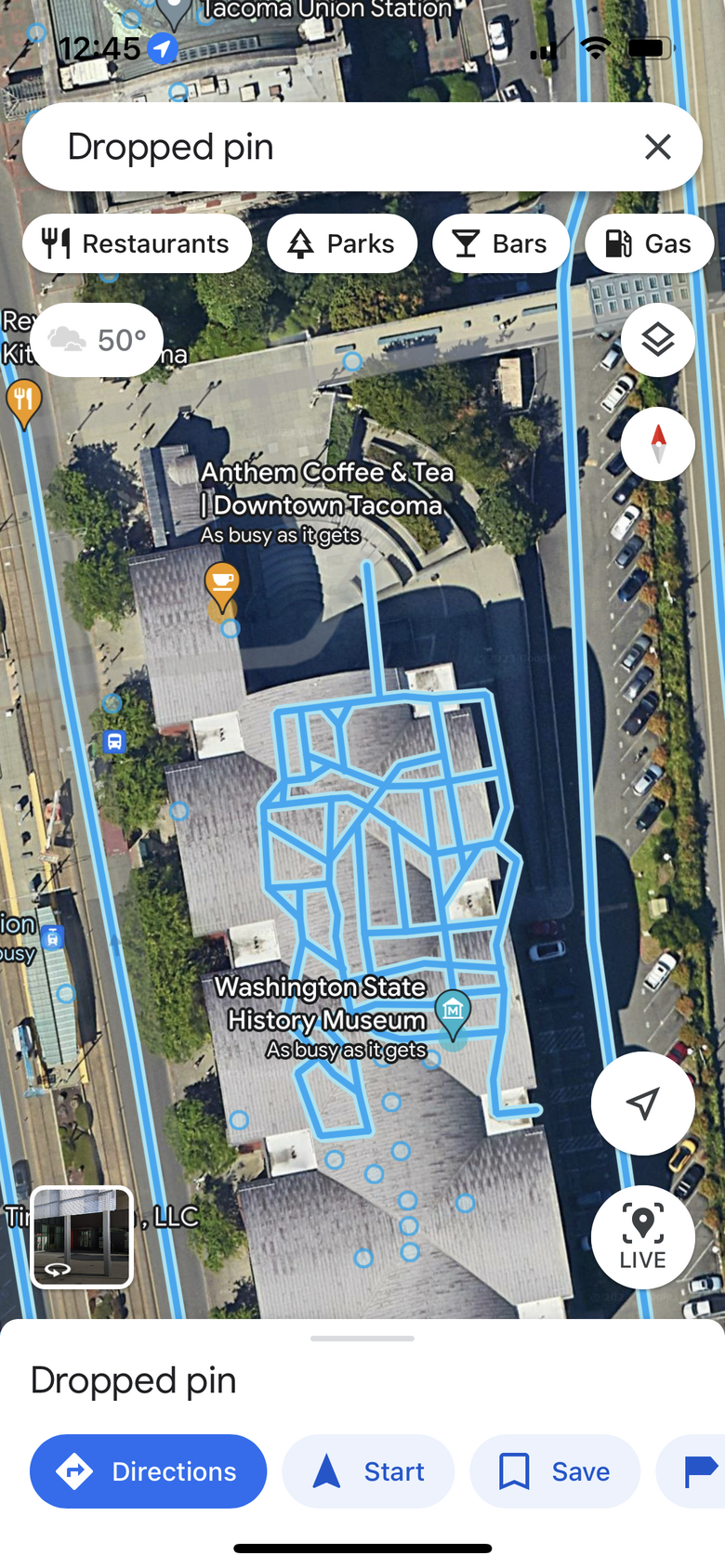 |
||
| Post 7 • IP flag post | ||
|
|
ron0987 private msg quote post Address this user | |
| @MeshImages Ntech Iris360 still available on eBay $250-1000, always was a good option, just not certain if Ntech supports it or the Istar system. | ||
| Post 8 • IP flag post | ||
|
WGAN Fan Club Member Queensland, Australia |
Wingman private msg quote post Address this user | |
Quote:Originally Posted by MeshImages I have tried pro3 for capturing mall streets outside. Unfortunately Matterport is no good for this way of capturing because it is not an instant capture for full 360. People walking around and they are ghosting in every 360. Here is my street view with a Pro3. I kind of did not expect anything better for captured people with a spinning camera. However if I am going to hit theme parks with an offer to map them a Pro3 would not be my choice unless I can do it before parks open and after they are closed. NCTech website is still there but cameras are out of stock for Pulsar cameras. I have checked ebay and they is one seller trying to unload his Fusion camera asking quite a little for it. However after short research it looks like Fusion has not been designed for Street View. More than for documenting. It is less resolution but comes with some compatibility to colour point clouds from LiDARs including Leica ones. NCTech Iris360 Pro claimed to be designed for Street View and it has 60MP resolution but I cannot see it listed anywhere for sale. I could not find any rentals for any NCTech cameras. |
||
| Post 9 • IP flag post | ||
|
WGAN Fan Club Member Queensland, Australia |
Wingman private msg quote post Address this user | |
Quote:Originally Posted by ron0987 Thanks. After your first message I went to check on ebay.com and I could see it. Ebay did not want to show me Iris360 cameras searching from ebay.com.au despite me looking worldwide. The you show with a link is non pro version that can only do 8K. Another seller selling a Pro version for $1000 got all items specifics for non pro and I am trying to confirm it with him whether I should trust his item title that says it is Iris360 Pro or everything else including the item description that mentions specs for non pro. Pro is 12K, non pro is only 8K. I'd rather pay $1000 for a Pro. |
||
| Post 11 • IP flag post | ||
|
WGAN Fan Club Member Queensland, Australia |
Wingman private msg quote post Address this user | |
| The guys with $1000 price has replied that his camera is not pro and he's made a mistake saying it is Pro in its title. | ||
| Post 12 • IP flag post | ||
|
|
ron0987 private msg quote post Address this user | |
| @Wingman I hope you did not commit to Nctech, I just got this from Mosaic Cameras “ Are you using an NCTech camera for your GSV captures? If so, are you aware of the recent changes that might impact your work? With VR.world shutdown, how will you access any of your previous projects or imagery annotations? The iOS app has been discontinued, and the Android version is outdated. High licensing fees from NCTech are a stark contrast to our no-extra-cost policy. The lack of updates and third-party support from NCTech could limit your capabilities. At Mosaic, we provide a robust alternative with zero recurring fees, up-to-date integrations, and a commitment to your continuous success in street view photography  ” ” |
||
| Post 13 • IP flag post | ||
|
WGAN Fan Club Member Queensland, Australia |
Wingman private msg quote post Address this user | |
Quote:Originally Posted by ron0987 Thanks Ron, I was only exploring this option. However I have seen somewhere that NCTech license is something in 4 figures a year. Nope, I won't pay that much or technically any license fee to publish to Google Maps.. because from Google side it is free. DO you have any info on Mosaic51 camera price? The company that distributes them in Australia is the same as distributing Leica. I have sent them a question about pricing. From another source I have found that subscription can be bought for a month for € 99 or € 699 for an annual subscription. At least you can do it when you have a client and just paying € 99 for using software for 30 days. Here you can get samples and see pricing for using Mosaic cameras. |
||
| Post 14 • IP flag post | ||
|
WGAN Fan Club Member Queensland, Australia |
Wingman private msg quote post Address this user | |
| got the price for Mosaic51 and it is $57000 AUD, with Christmas special now about $45000 Their version with a Lidar is over $90000 AUD. I am sure Google can afford it but I highly doubt anybody else can. I am definitely out. It will be significantly cheaper to build my own even from 5x full frame Sony A7RiV or even much cheaper to use a few APS-C sensor cameras. Stitching videos can be a problem but I am sure it is doable. Plus there is still an Insta360 Titan which I hope does a better quality that their Insta Pro 1 or Pro 2. I have owned their Pro1 for a week or so and I must say Pilot Era makes a better quality than a Pro1. |
||
| Post 15 • IP flag post | ||
|
|
ron0987 private msg quote post Address this user | |
| @Wingman ya I got the prices too, when the original email came out. I thought it was geared toward the basic camera, but these are geared strictly toward the mobile vehicle mounted service. Your right on the MONEY, Google can afford it but this is definitely not in my budget and even if it was I don’t think there would be any need in my area for it and then no return on investment. Not a good business model for me. | ||
| Post 16 • IP flag post | ||
|
|
ron0987 private msg quote post Address this user | |
| @Wingman have you look at the Insta360 RS1, I have used the X3 and was amazed at the quality under $500, both video and individual 360 panoramic shots very good. In the editing software you can extract individual panoramic shots from video, the best of both worlds under $1000, US dollars. | ||
| Post 17 • IP flag post | ||
Pages:
1This topic is archived. Start new topic?