Exterior drone mapping for building condition survey15742
Pages:
1

|
srennick private msg quote post Address this user | |
| Hey there, Do we have any surveying specialist utilizing aerial drones for exterior building mapping of high rises? What are the types of drones that are generally used or recommended for this type of work? What are the camera specs? What software is generally used, like Drone Deploy or something better? |
||
| Post 1 • IP flag post | ||
 WGAN Forum WGAN ForumFounder & WGAN-TV Podcast Host Atlanta, Georgia |
DanSmigrod private msg quote post Address this user | |
| Video: BLK2FLY Autonomous Reality Capture | Video courtesy of Leica BLK YouTube Channel | 7 September 2021 @srennick Is this video (above) helpful? (While I am not a drone pilot, I did stay at a Holiday Inn last night.) WGAN Forum discussions tagged: Skydio Enjoy your weekend. Dan |
||
| Post 2 • IP flag post | ||
|
|
ron0987 private msg quote post Address this user | |
| @srennick how tall a building are you talking about? It will just depend on size and accuracy that you require or client needs. | ||
| Post 3 • IP flag post | ||
|
|
PBStone1 private msg quote post Address this user | |
| The video is very well produced, but misleading. First and foremost, you need an FAA 107 license to fly the drone in US airspace (other countries have similar requirements). Secondly, a vast majority of buildings will be in metropolitan areas and likely in restricted airspaces, which require waivers. There are several other regulatory, safety and practical restrictions that make drone facade inspections a very complex (although possible) undertaking. The video suggests that if you're willing to spend the money, you can just push a button and go; and this is definitely not the case. Finally, there are far more affordable alternatives to laying down upwards of $50,000 USD to conduct a facade inspection. While LIDAR is great, it is likely unnecessary for a facade inspection. In almost all cases, photogrammetry will provide better deliverables at a fraction of the cost. There are several reputable Drone Service Providers that are qualified and have the expertise to perform facade inspections. If you are looking to do it yourself, the first step is to obtain your Part 107 license. In the meantime, there are several professional groups and forums available that can point you in the right direction for the best hardware and software solutions. |
||
| Post 4 • IP flag post | ||
 WGAN Forum WGAN ForumFounder & WGAN-TV Podcast Host Atlanta, Georgia |
DanSmigrod private msg quote post Address this user | |
Quote:Originally Posted by ron0987 @ron0987 Do you ask about the height of the building because the Leica BLK360 range might be sufficient since it captures data for a much greater distance than a Matterport Pro2 3D Camera and the BLK360 can scan outdoors? Dan |
||
| Post 5 • IP flag post | ||
|
|
ron0987 private msg quote post Address this user | |
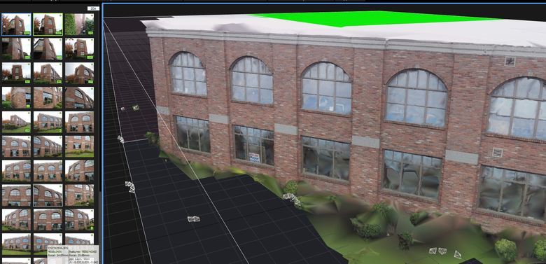
| @DanSmigrod your right on the money depending on the average project you can scan from the ground. I worked with several contractors that scanning from ground level covered the complete façade. @PBStone1 you are correct about the FCC requirements but again you are investing a little bit of money for most good software, drone and depending software some fall short on verticals and restrictions to fly drones in and around a building and get detailed shots. Also depending on the height I agree with the photogrammetry is a fast inexpensive resolution. In this photo I got good resolution from the ground.  If higher you can mount a camera on painters pole and with remote trigger and take photos. But if I had the money I would buy the drone in a heartbeat. |
||
| Post 6 • IP flag post | ||

Houston |
briangreul private msg quote post Address this user | |
| It really depends on what you want to do. Are you looking to hire someone? or offer the service? |
||
| Post 7 • IP flag post | ||
 WGAN Fan WGAN FanClub Member Queensland, Australia |
Wingman private msg quote post Address this user | |
| Getting waivers on flights even for short ones is not that easy. In my area a pilot license won't get you anything. You need to have an drone operator license, submit an application, pay $800 app fee and you may end up with No. I was trying to get one for a race club and this was only for 5 minutes airborne top as I needed only an ariel 360. I was seeking for one because a client wanted it but they are at the edge of international airport zone. I was told to go through a 3rd party with an operator license but the outcome most likely to be No even for 30m height, 5 minutes airbourne and all eyes on a drone only. CASA(aviation authority in Australia) guy also mentioned that the only way an operator can get a waiver there if their drone is tethered to the ground. I believe most of drone operators do not have it. |
||
| Post 8 • IP flag post | ||
 WGAN Fan WGAN FanClub Member Queensland, Australia |
Wingman private msg quote post Address this user | |
| BTW if you look at my topic with BLK360+Pro2 job you can see that my BLK360 reached 7th floor facade from a 1.5m height but density of data at top floors is not that good. However if we are talking about 2-4 storey building it may do a job assuming you will be using a high pole to add scans from a higher level. | ||
| Post 9 • IP flag post | ||

Houston |
briangreul private msg quote post Address this user | |
| I've not had those issues in the USA. But the process takes time and there is a method to it. I've successfully flown at a busy international airport with ATC coordination. | ||
| Post 10 • IP flag post | ||

|
srennick private msg quote post Address this user | |
| @ron0987 It is 57 stories. | ||
| Post 11 • IP flag post | ||
|
|
ron0987 private msg quote post Address this user | |
| @srennick, wow, drone is just about your only option. Good luck keep us updated. I do not have enough info for you to give advice on vertical services that high for equipment or software. | ||
| Post 12 • IP flag post | ||

|
EaglePrecision private msg quote post Address this user | |
| You need a drone with software that has a vertical mapping function - I haven't checked lately, but I believe either DroneDeploy or Pix4D has it. You'll need to sing up for one of those to get the photos stitched and processed. You will only be able to do it on a cloudy day, otherwise the results will be too noisy. DroneDeploy service is your best option to upload the photos because it is the easiest to learn & use. If you want to do it yourself, you could stitch the photos into a 3D model using photogrammetry software such as Metashape. None of this will be cheap nor easy for a first-time user. You'd be better off contracting a drone service provider who has experience with photogrammetry. |
||
| Post 13 • IP flag post | ||
 WGAN Forum WGAN ForumFounder & WGAN-TV Podcast Host Atlanta, Georgia |
DanSmigrod private msg quote post Address this user | |
 @srennick Quote: Originally Posted by @EaglePrecision If you decide to outsource, this WGAN Cheat Sheet – free access for WGAN Forum Members – includes nine nationwide aerial photography services to help you source a drone service provider that has the expertise for your project. ✓ CHEAT SHEET: 60+ Companies Seeking MSPs to Shoot Matterport/HDR Photos Gigs Please let us know how you end up handling this project. Best, Dan |
||
| Post 14 • IP flag post | ||
 WGAN Forum WGAN ForumFounder & WGAN-TV Podcast Host Atlanta, Georgia |
DanSmigrod private msg quote post Address this user | |
| @srennick I could imagine that DroneDeploy will make some announcements at DroneDeploy Conference 2021 next week (19-20 October 2021) that may be helpful in your decision making for your project. Best, Dan |
||
| Post 15 • IP flag post | ||
Pages:
1This topic is archived. Start new topic?


