


Video Training: Learning Pix4D Drone Mapping12214
Pages:
1
 WGAN Forum WGAN ForumFounder & WGAN-TV Podcast Host Atlanta, Georgia |
DanSmigrod private msg quote post Address this user | |
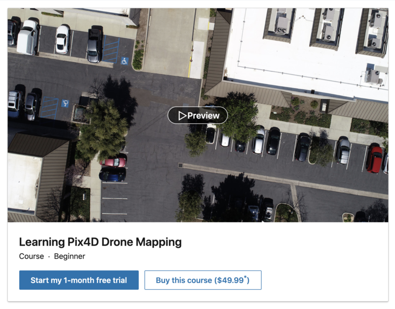 Screen Grab: Video Training: Learning Pix4D Drone Mapping Hi All, Here is a course ($9.99) in learning Pix4D Drone Mapping: ✓ [url=https://www.linkedin.com/learning/learning-pix4d-drone-mapping/]Learning Pix4D Drone Mapping The course instructor is Paul Tice, whom was my guest on WGAN-TV Live at 5: ✓ Transcript: WGAN-TV How to Make Money with Matterport in the AEC Space Paul's credentials include: ✓ teaches a Lynda.com/LinkedIn Learning Class, Matterport 3D Scanning and Visualization ✓ consultant in the AEC Space for visualization and scanning of spaces and objects ✓ running workshops for: universities, non-profits and professionals ✓ training for FARO and Matterport ✓ speaking at SPAR3D on rapid documentation of construction projects using LiDAR and Matterport ✓ Journalist for AEC Space trade-publications: LiDAR Magazine and SPAR 3D ✓ Licensed sUAS (Drone) pilot ✓ 20+ years of experience: Survey, CAD, GIS and 3D scanning projects ✓ Project Engineering and training teams on implementing various 3D technologies for construction and design; Creating accurate as-builts/site plans for large, complex buildings, structures and landscapes; Licensed sUAS (Drone) pilot; Photogrammetry Mapping and Reality Modeling; Creating and delivering project Visualizations/Presentations to stakeholders. ✓ Matterport Service Provider Course Outline for Learning Pix4D Drone Mapping Introduction ✓ Drone mapping(Viewed) ✓ Save Drone mapping 1. The Art and Science of Photogrammetry ✓ What is photogrammetry? ✓ Save What is photogrammetry? 2. Federal Aviation Administration (FAA) ✓ Getting Part 107 certified: sUAS remote pilot ✓ Save Getting Part 107 certified: sUAS remote pilot ✓ Understanding airspace ✓ Save Understanding airspace ✓ Air Map ✓ Save Air Map 3. Getting Started ✓ Which mapping drone and camera are right for you? ✓ Save Which mapping drone and camera are right for you? ✓ Pix4Dbim: Mapper, fields, and model ✓ Save Pix4Dbim: Mapper, fields, and model 4. Pix4Dcapture App ✓ Using the Pix4Dcapture app to choose a mission: Part 1 ✓ Save Using the Pix4Dcapture app to choose a mission: Part 1 ✓ Using the Pix4Dcapture app to choose a mission: Part 2 ✓ Save Using the Pix4Dcapture app to choose a mission: Part 2 5. Your First Flight ✓ Preflight checks ✓ Save Preflight checks ✓ Downloading and naming your data ✓ Save Downloading and naming your data 6. Coordinate Systems and Projections Overview ✓ The mathematical model of Earth in Pix4D ✓ Save The mathematical model of Earth in Pix4D 7. Pix4D Desktop: Introduction ✓ Overview of Pix4D: Creating your first project ✓ Save Overview of Pix4D: Creating your first project ✓ Coordinate systems and projections ✓ Save Coordinate systems and projections ✓ Processing options template ✓ Save Processing options template ✓ The Pix4D Map View interface ✓ Save The Pix4D Map View interface ✓ Definitions: Densified point cloud, 3D textured mesh, DSM, DTM, and so on ✓ Save Definitions: Densified point cloud, 3D textured mesh, DSM, DTM, and so on ✓ Initial processing: General ✓ Save Initial processing: General ✓ Initial processing: Matching ✓ Save Initial processing: Matching ✓ Initial processing: Calibration ✓ Save Initial processing: Calibration ✓ Creating the quality report ✓ Save Creating the quality report ✓ Quality checking your data ✓ Save Quality checking your data ✓ Processing the point cloud ✓ Save Processing the point cloud ✓ Generating a 3D textured mesh ✓ Save Generating a 3D textured mesh ✓ Advanced processing options ✓ Save Advanced processing options ✓ Processing DSM and orthomosaic ✓ Save Processing DSM and orthomosaic ✓ Additional outputs for DSM, orthomosaic, and index ✓ Save Additional outputs for DSM, orthomosaic, and index ✓ Using the Index Calculator toolset ✓ Save Using the Index Calculator toolset ✓ Choosing your output coordinate system ✓ Save Choosing your output coordinate system ✓ Uploading to the cloud for processing ✓ Save Uploading to the cloud for processing 8. Pix4D Desktop: Advanced Processing ✓ GCP: Creating a high-precision project, part 1 ✓ Save GCP: Creating a high-precision project, part 1 ✓ GCP: Creating a high-precision project, part 2 ✓ Save GCP: Creating a high-precision project, part 2 ✓ GCP: Creating a high-precision project, part 3 ✓ Save GCP: Creating a high-precision project, part 3 ✓ GCP: Creating a high-precision project, part 4 ✓ Save GCP: Creating a high-precision project, part 4 ✓ GCP: Creating a high-precision project—rayCloud Editor ✓ Save GCP: Creating a high-precision project—rayCloud Editor ✓ MTP: Enhancing precision through manual tie points ✓ Save MTP: Enhancing precision through manual tie points ✓ Splitting and merging large projects, part 1 ✓ Save Splitting and merging large projects, part 1 ✓ Splitting and merging large projects, part 2 ✓ Save Splitting and merging large projects, part 2 ✓ Splitting and merging large projects, part 3 ✓ Save Splitting and merging large projects, part 3 ✓ Splitting and merging large projects, part 4 ✓ Save Splitting and merging large projects, part 4 ✓ rayCloud interface and basic features ✓ Save rayCloud interface and basic features ✓ rayCloud editing ✓ Save rayCloud editing ✓ Annotation tools ✓ Save Annotation tools ✓ Volume calculator ✓ Save Volume calculator ✓ Mosaic Editor ✓ Save Mosaic Editor ✓ Thermal mapping ✓ Save Thermal mapping 9. Pix4D for AEC ✓ AEC application: 3D scans and Pix4D ✓ Save AEC application: 3D scans and Pix4D 10. Pix4D Support and Certification ✓ How to search for help and resources Source: Learning Pix4D Drone Mapping Are you using Pix4D for drone mapping? Dan |
||
| Post 1 • IP flag post | ||
 WGAN WGANStandard Member Cayman Islands |
Harrycayman private msg quote post Address this user | |
| Hi dan looks like a great course. When i click the cost is 49.99 .Not 9.99 am i missing something harry |
||
| Post 2 • IP flag post | ||
|
WGAN Forum Founder & WGAN-TV Podcast Host Atlanta, Georgia |
DanSmigrod private msg quote post Address this user | |
| @Harrycayman I check with the Instructor, Paul Tice, and the course is $49.99. I (just) fixed the screen grabs and links above. Dan |
||
| Post 3 • IP flag post | ||
|
WGAN Forum Founder & WGAN-TV Podcast Host Atlanta, Georgia |
DanSmigrod private msg quote post Address this user | |
| Video: Pix4D - Product Overview 2020 | Video courtesy of Pix4D YouTube Channel | 27 July 2020 | ||
| Post 4 • IP flag post | ||
Pages:
1This topic is archived. Start new topic?