


Ricoh Theta Z1 Assisted Alignment via Matterport April Tags?12164
Pages:
1

|
Atriux private msg quote post Address this user | |
| Hi Guys , New to the forum . I read on MP website about assisted alignment for big spaces & repetitive situations thru QR codes aka April Tags . Was wondering, if the 360 cameras ( theta Z1 in this case )can read them? Although inside , i had no problems , outside is a different thing. I tried and is getting messy with the scan alligments using 360 pics 3D conversion thru Cortex. I have latest updates & firmware. I'm making a showcase for furnished & vegetation outdoor roof deck ( 5K SF ) in a residential building . Scheduled in 2 days! . Any input is appreciated. Thank You . |
||
| Post 1 • IP flag post | ||

|
RichardStanton private msg quote post Address this user | |
| With 360 alone that's going to be a rough one. I have experimented with machine tagging on spherical conversions and they either don't work or at least have not been effective for me. The most consistent solution I have found is good old fashioned geometry. I do not know the space, but if you can work with the client to set out some solid hit geometry (angular faces, no black or shiny objects, etc.) near crucial bridging scan points I have found very effective. Generally speaking picking objects that are a hit in at LEAST two scan points can be sufficient. Less than that and it is not much of a help. Another huge suggestion is to make sure you point the "front" of your camera toward any object you are seeking the best fix from (by front I mean whichever side of the two hemispheres acts as the front for default orientation, for the Insta360 One X this is the side with the control buttons for instance ) If you don't know which is the primary or front hemisphere you can either work it out quickly looking at a live view, or just make sure that you don't have an important object for alignment on the seam line, this will almost always cause your alignment to go to hell. Last, be as consistent with your alignment as you can be, it's not so much an issue for other spaces, but up there you are going to want each overlap to be as similar as possible (which means keeping the horizontal orientation of your camera consistent if possible). Also don't be afraid to take a scan, watch the mini map and get an idea of what kind of point cloud you have forming around you. If you see few or no hits in all directions you probably will need to adjust something physical around you, or your location. Every environment is unique of course, but I hope some of this will be useful in your endeavor! |
||
| Post 2 • IP flag post | ||
|
|
Atriux private msg quote post Address this user | |
| Richard , that's good input ( TY ) . If the April Tags are not reliable, why we have assisted alignments option on MP app ? ( the QR tags are accurate 99% according to the developers ) I know about the orientation / hemispheres ) and keeping track on that . I calculate the space . Around 5K SF should give me 100 shots aprox . Also some shots on higher elevation need be ( where ?) . Is that correct assumption ? See a floor plan of the space with the marked shots . 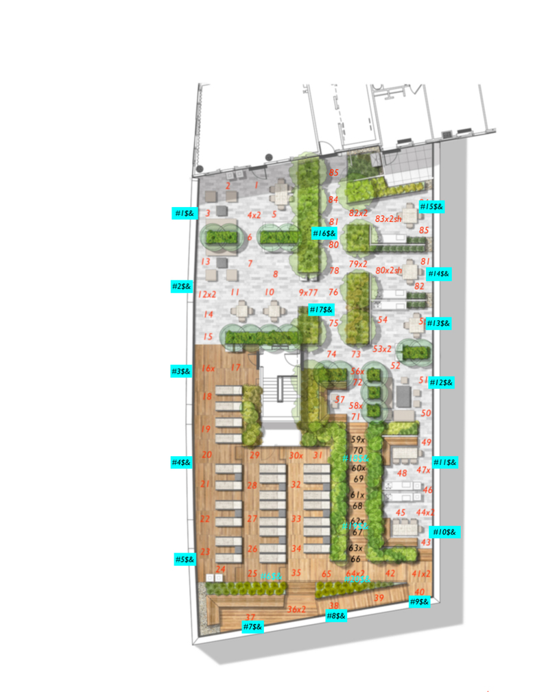 |
||
| Post 3 • IP flag post | ||
|
|
RichardStanton private msg quote post Address this user | |
| That's very admirable pre-work @Atriux! |
||
| Post 4 • IP flag post | ||
Pages:
1This topic is archived. Start new topic?