National Scanning Company Seeks Platform for 1,000 360/3D Virtual Tours9979
Pages:
1
 WGAN Forum WGAN ForumFounder & WGAN-TV Podcast Host Atlanta, Georgia |
DanSmigrod private msg quote post Address this user | |
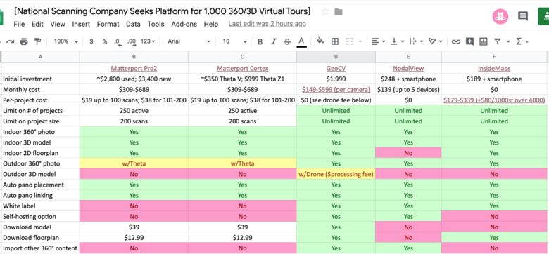
 Screen Grab from this Google Sheet Hi All, Which platform do you recommend? [National LiDAR Scanning Company in the AEC Space] has reach out to me seeking a recommendation for a 360º or 3D virtual platform for 1,000 Virtual Tours (360º or 3D) annually. "We are potentially looking at well over a thousand of these [Virtual Tours] per year as a value-add alongside our traditional [high-end LiDAR scanning in the AEC space] deliverables. Property types will range from franchise retail to hotels to industrial campuses, so our main focus is speed and efficiency both on-site and post-production. These will be used internally by our clients, so image quality is not as important as automation of the process [capture, post production]." Deliverable ✓ "360° virtual tour linked to an interactive 2D floor plan and/or 3D model" Requirements ✓ Automatic constellation layout ✓ Automatic pano linking ✓ Automatic floor plan and model creation ✓ White label ✓ Self-hosting or restricted access ✓ No limits on # of projects or project size Nice to Have ✓ Dollhouse view ✓ Ability to download floor plan and model ✓ Ability to include exterior drone imagery The [National Scanning Company] provided this Google Sheet of their research (as of 12 August 2019). ✓ Matterport Pro2 versus Matterport Cortex versus GeoCV versus Nodalview versus Inside Maps (Google Sheet) Backstory "Thanks for taking the time to send those links, Dan." "Here’s a little more detail. The vast majority of our projects are typically delivered in AutoCAD or Revit. Occasionally we would be asked for 360° panos linked to a 2D floor plan, which we would deliver in an interactive PDF linked to a virtual tour built in Pano2VR. Now that we are receiving more and more requests for this, we are looking for an automated solution to remove the added labor of manual pano placement and tour building from our process." "So, our most important criteria are automatic placement and linking of the panos and automatic creation of a 2D floor plan. A 3D “dollhouse” model is also desirable to some of our clients. Matterport doesn’t meet our needs on some other important criteria like project limitations, white labeling, and self-hosting." I’ve also experimented with Cupix since their beta program ... Some of our projects are very large facilities ..." "Based on the attached spreadsheet [above] I created, GeoCV seems to be the best fit for us (especially with the ability to incorporate exterior drone photos into the 3D model) unless you know of another device/solution I’m not aware of." "I do appreciate the wealth of knowledge on the WGAN Forum and I’ve spent quite a bit of time there ..." -- "... Our primary clients are architects and developers preparing for commercial renovation projects. Typically we use Faro scanners and a NavVis trolley to collect precise measurements and imagery for AutoCAD, Revit, and BIM. However, some of our clients have been asking about Matterport and other options for a less expensive (meaning without precise measurements) way to visualize their spaces. We have looked at Matterport and had several conversations with them, but we need something with a more open ecosystem and GeoCV looks like it might be the solution." --- Your platform recommendation? Best, Dan |
||
| Post 1 • IP flag post | ||

|
leeverdon private msg quote post Address this user | |
| Hi Dan, What about the IMS-5 iGuide camera and platform as another option? Lee |
||
| Post 2 • IP flag post | ||
 iGUIDE iGUIDEFounder/CEO Kitchener, Canada |
Alex_iGuide private msg quote post Address this user | |
@leeverdon - Thanks for mentioning iGUIDE. Here is how iGUIDE features compare. Wish speed and accuracy ranking was used as well: https://store.goiguide.com/iguide-camera/ims-5/ https://goiguide.com/processing |
||
| Post 3 • IP flag post | ||
 WGAN WGANStandard Member Los Angeles |
Home3D private msg quote post Address this user | |
| In the list of six "requirements", GeoCV seems to satisty the most. And the comment about the Outdoor 3D mode, that's only GeoCV as far as I'm aware. The sixth item on the list is GeoCV's only shortcoming, being like Matterport when it comes to large site limits. I've heard Matterport has an absolute ceiling around 1000 scans, that it simply will crash near there. GeoCV, I'm not aware but I've shot GeoCV in HD mode up to around 400 scans. Presumably in SD mode it could be higher. Perhaps Anton can weigh in. | ||
| Post 4 • IP flag post | ||

San Francisco |
Jwbuckl private msg quote post Address this user | |
| This comparison chart seems about right with a couple of exceptions if I am reading this correctly. For Matterport, "Outdoor 360 Photos" can indeed be accomplished with both Thetas as mentioned above but also the Pro2. And thanks to Cortex, you can now use the Pro2 to produce "Outdoor 3D Models" with 360 to 3D conversions so I wouldn't have two "no's" in the boxes. Like this model shot entirely outdoors. This model produced by True Markets 3D Scanning out of Madaba Governorate, Jordan. Others like to create a blended outdoor/indoor models with Matterport by blending the use of the Theta Z1 and the Pro2 much like photographer Harlan Hambright does here in this model where all outdoor imagery is handled by the Z1: |
||
| Post 5 • IP flag post | ||
 WGAN WGANStandard Member Los Angeles |
Home3D private msg quote post Address this user | |
| @Jwbuckl - Thanks for posting these. Dead Sea Panorama is impressive. As I've worked more with GeoCV recently, I now use the terminology "Exterior 3D" or "Outdoor 3D" as referring to the drone 3D modeling GeoCV has made possible, such as the example below. This offers an overview of the entire property and can be combined with aerial panos which view miles to the horizon via GeoCV's open structure which permits panos shot by other camera systems, such as drone, to be incorporated into the presentation "Highlights" thumbnails. So many options we now have for presenting properties virtually. |
||
| Post 6 • IP flag post | ||
 WGAN Forum WGAN ForumFounder & WGAN-TV Podcast Host Atlanta, Georgia |
DanSmigrod private msg quote post Address this user | |
| @Jwbuckl @Home3D Thank you for sharing these AMAZING examples. What's now possible indoors and now outdoors is super-exciting. Dan |
||
| Post 7 • IP flag post | ||
 WGAN Forum WGAN ForumFounder & WGAN-TV Podcast Host Atlanta, Georgia |
DanSmigrod private msg quote post Address this user | |
Quote:Originally Posted by @Jwbuckl For clarification, Dead Sea Panorama by True Markets 3D Scanning out of Madaba Governorate, Jordan was shot with 360º Views that Matterport Cortex converted to 3D? Best, Dan |
||
| Post 8 • IP flag post | ||
 WGAN WGANStandard Member Los Angeles |
Home3D private msg quote post Address this user | |
| Looked to me like it was scanned in traditional fashion after dusk. As I "walked" down one path, seeing direct sunlight up ahead, as I "stepped" into the sunlit portion it turned to after dusk. So looks like traditional scanning where you dash around scanning everywhere direct sunlight is not present and then continue scan paths after dusk but before total darkness. My speculation. Would love to hear from the source! | ||
| Post 9 • IP flag post | ||
 WGAN Forum WGAN ForumFounder & WGAN-TV Podcast Host Atlanta, Georgia |
DanSmigrod private msg quote post Address this user | |
| @Home3D Your example is AMAZING! I Dan |
||
| Post 10 • IP flag post | ||

San Francisco |
Jwbuckl private msg quote post Address this user | |
| @Home3D @DanSmigrod As a drone pilot/photographer myself, I find the drone to scan integration to be impressive and super interesting. Personally, I would love to see this executed by Matterport in the future. Thank you for sharing. | ||
| Post 11 • IP flag post | ||
 WGAN Forum WGAN ForumFounder & WGAN-TV Podcast Host Atlanta, Georgia |
DanSmigrod private msg quote post Address this user | |
| Hi All, I reached out to my contact at the [National LiDAR Scanning Company in the AEC Space] to ask him for his thoughts about the discussion above. He gave me permission to post his comment. He writes: "I’ve looked at iGuide previously. Although it looks like a nice solution for real estate listings, it doesn’t have the scalability or flexibility we need for large commercial properties. GeoCV also has the potential of upgrading the hardware with better phones and depth sensors and Cupix is hardware-agnostic so those are also factors we are keeping in mind." Best, Dan |
||
| Post 12 • IP flag post | ||
 WGAN WGANStandard Member Los Angeles |
Home3D private msg quote post Address this user | |
| I also would like to see MP engage on Drone 3D, but I doubt they will. Company is too large and this is too niche. And we’re it to come from an aftermarket source, it might require MP to open up their coding. This and white label I doubt they will ever do. | ||
| Post 13 • IP flag post | ||

|
Convrts private msg quote post Address this user | |
Quote:Originally Posted by Home3D This is ace Home3D, did you create the model with Pix4D / Dronedeploy / other before adding it to the tour? I know there are different options but this looks great. I'm just about to do a few similar sites so any tips would be greatly received! |
||
| Post 14 • IP flag post | ||

|
Convrts private msg quote post Address this user | |
Quote:Originally Posted by Home3D Great to hear you have used GeoCV up to 400 scans Home3D! I was told that it was a 200 HD / 500 SD hard limit. I asked support the question because the app starts to give a warning notification every couple of scans and the numbers all turn red as you approach 200 and kind of suggests it wont let you go over but it's really good to know that it won;t just stop at 200. If you can actually do 400 in HD then using those figures SD should be actually around 1000 which is amazing!?! |
||
| Post 15 • IP flag post | ||
 geoCV geoCVDirector of Operations |
sameerak private msg quote post Address this user | |
Quote:Originally Posted by Convrts Hey @Convrts In one of our recent updates of the GeoCV Scanner App, we have incorporated actual hard limits at 200 HD points and 500 SD for scanning. @Home3D was able to capture the 200+ HD scan before this update was released. So for now, these are the hard limits. Hope this clarifies your thoughts! |
||
| Post 16 • IP flag post | ||
 WGAN WGANStandard Member Los Angeles |
Home3D private msg quote post Address this user | |
| Yes, for the present time, it's essential on GeoCV to anticipate whether you will exceed 200 scans. If you might, set the camera to SD (uncheck the HD option). This is currently a HARD limit, not a suggestion or approximation. | ||
| Post 17 • IP flag post | ||

|
Convrts private msg quote post Address this user | |
Quote:Originally Posted by sameerak This was as I understood it ... I was just confused (and over excited!) when there was mention of @Home3D saying he'd done 400 HD. That clears it up thanks Sameer Quote: Originally Posted by Home3D Yes that's as I understood it @Home3D it was your mention of 400 HD scans which confused me .... Thanks for clearing it up! |
||
| Post 18 • IP flag post | ||
Pages:
1This topic is archived. Start new topic?


