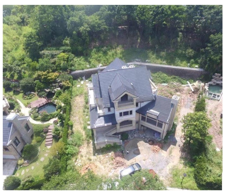
Landscape CAD8313
Pages:
1|
|
Tette99 private msg quote post Address this user | |
I’ve got a client who’s a landscape designer. They would like to use Matterport scans of the outside of the surrounding home and get CAD drawing along with elevation measurements to conduct landscape design, is this possible.  |
||
| Post 1 • IP flag post | ||
 WGAN WGANStandard Member Bon Secour, Alabama |
Chemistrydoc private msg quote post Address this user | |
| Difficult because of the sensitivity of Matterport to daylight. Better would be the Leica BLK360, which you can use with Matterport Capture. KF |
||
| Post 2 • IP flag post | ||
|
|
Tette99 private msg quote post Address this user | |
| But what if I don’t have access to a Leica? Would it be possible if I scanned around the perimeter of the home and during dusk while the sun is minimal? Would that be sufficient to provide enough data for a CAD and elevation stats? | ||
| Post 3 • IP flag post | ||
 WGAN WGANStandard Member Bon Secour, Alabama |
Chemistrydoc private msg quote post Address this user | |
| Sure, you can do that,but it may take multiple dusks to accomplish it. I can't state unequivocally that quality of the data is sufficient for CAD / elevation, but my feeling is that it is. | ||
| Post 4 • IP flag post | ||

Hartland, Wisconsin |
htimsabbub23 private msg quote post Address this user | |
| I'd love to see this in action. I'm actually a landscape designer by trade and though I've thought about trying this many times I barley can get a deck to scan right with any hint of sun. | ||
| Post 5 • IP flag post | ||
 WGAN Fan WGAN Fan Club Member Portland, Oregon |
HelloPado private msg quote post Address this user | |
| Will you share the address of the home. I can get a geo location into sketchup and see what I can do. The lot looks pretty level. Do you know what they are trying to accomplish? You can get tremendous data from a drone capture with Pix4D too. Edit: Because the lot is so flat, the camera is going to have data to scan. |
||
| Post 6 • IP flag post | ||
 WGAN Forum WGAN ForumFounder & WGAN-TV Podcast Host Atlanta, Georgia |
DanSmigrod private msg quote post Address this user | |
Quote:Originally Posted by @HelloPado @Tette99 WGAN Forum discussions tagged: PIX4D https://www.wegetaroundnetwork.com/tag/pix4d Dan |
||
| Post 7 • IP flag post | ||
|
|
Tette99 private msg quote post Address this user | |
| The address is in China actually where google is restricted |
||
| Post 8 • IP flag post | ||
|
|
Tette99 private msg quote post Address this user | |
| I’m actually going to have a mavic pro with me along with the Matterport. I’m not quite sure what to capture with the drone to use with Pix4D. | ||
| Post 9 • IP flag post | ||

|
immersivespaces private msg quote post Address this user | |
| If you are going to be doing accurate CAD files, you'll want to use a Leica BLK360 or another LiDAR system with more accurate measurements. The approximations from Matterport, especially on the elevations, are not good enough in most cases. The Pix4D option is ok, but the process of getting a CAD file made out of that point cloud is a bit of a mess. | ||
| Post 10 • IP flag post | ||
|
|
Tette99 private msg quote post Address this user | |
| At this point the only options I have is MP with drone. What about drone deploy vs pix4D? Any recommendations? | ||
| Post 11 • IP flag post | ||
 WGAN Fan WGAN Fan Club Member Portland, Oregon |
HelloPado private msg quote post Address this user | |
| Im biased toward Pix4D because of its overall service and quality of output deliverables. I've used drone Deploy also. Either are suitable for your application. Although... neither will be beneficial for surveying terrain because you're working with what looks like a level lot. For kicks and giggles... will you give me the address and let me see what i can find. |
||
| Post 12 • IP flag post | ||
Pages:
1This topic is archived. Start new topic?


