Suggestions on Large Scan (12 unit building)6335
Pages:
1|
|
plorenz private msg quote post Address this user | |
| Hi everyone! I'm preparing to scan a 12 unit loft style building. I've done 40 or so scans but this will be my first time scanning a property of this size (approximately 10-12,000 sqft). I'm eager to add the space to my portfolio and also want to give the Realtor usable materials to market his listings. The building is an L-shaped, vacant 2 story modern with soaring ceilings and 2 entrances (one on each leg of the L). I have a few specific questions about large scans and appreciate any insight that anyone can share. -I'm debating between scanning the property as a whole or scanning each individual unit as 12 files. It would be great if there was a way to scan the entire space and present versions of the tour both ways? Dan- could I scan the space, make copies and isolate select scan points to present each unit individually? -From reading previous threads it sounds like I wont really have a problem scanning a 10,000 sqft empty space. Anyone have feedback on loading issues related to large scans? -I don't know much about the ThreeSixty Tours: 2D Photo/Tour Maps but I'm wondering if this would help me to feature the building and each unit seamlessly. Does anyone have any experience with the service? Thanks to everyone that chimes in!! |
||
| Post 1 • IP flag post | ||

|
VRimpact private msg quote post Address this user | |
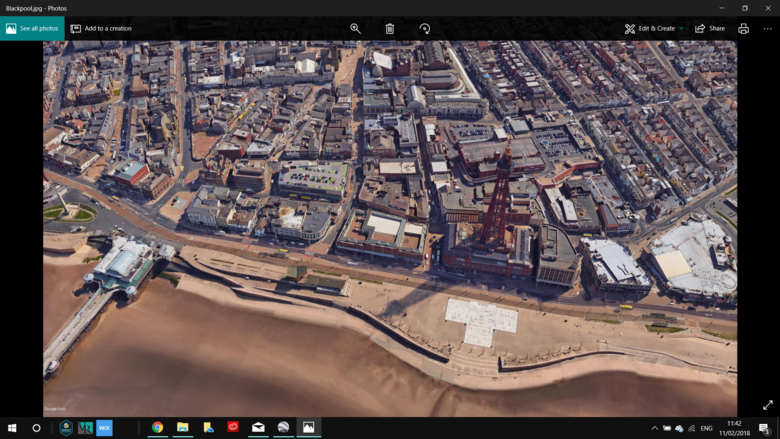
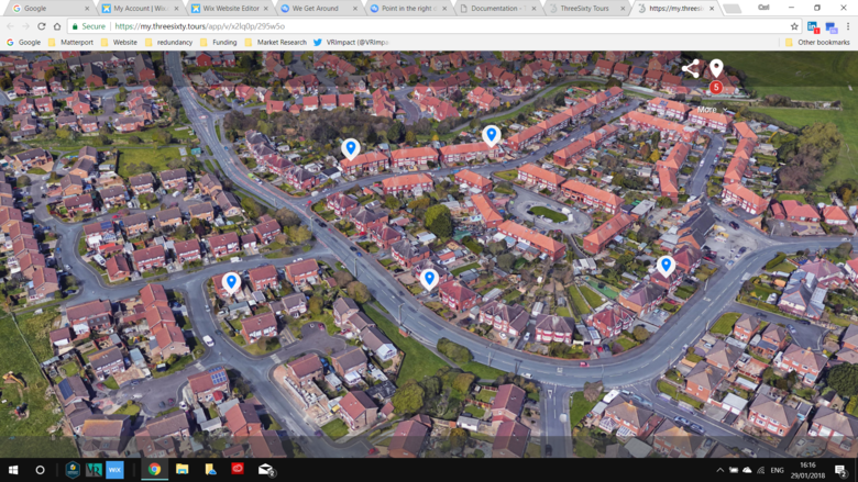
| Hi @plorenz . In my opinion you would be better doing a full scan and then if you choose you can make a duplicate and crop to a smaller scan should you need to do them as 12 individuals. I always think its better to do the one scan not 12 as you can always take them apart but more restricted putting them together. Also, be prepared for your Ipad to slow down towards the end with the higher data useage and make sure you have enough space on the device before you start scanning. Ive recently started using ThreeSixty and I feel I missed a trick the past 12 months as this platform is amazing to showcase larger areas or larger buildings if you can get a clear drone image or 360° Not Sure if this will help or is relevant to you, but for those who want to use ThreeSixty but are strugling to get a Drone shot of an area or dont want to pay out for a drone image, try this. Google Earth has its 3D buildings option. If your area is lucky enough to be already be created in 3D then you can simply zoom in on Google Earth and use its photo tool to take a high resolution image of the 3D area. Ive Attached one I used for my Three Sixty Shoot of Blackpool in the UK. Whilst on the screen / Google Earth Viewer it looks not very clear, when you save the view as an image you can select a resolution higher than 4K making it look better on the downloaded image. You may already know this trick but its hand to know for people who want to use ThreeSixty Tours for a larger geographic area. University Campus's in the UK are keen for this style of map with their tours. That can sometimes showcase dozens of virtual tours on the one image. Hope this helps... Images uploaded on here are restricted to less than 5MB in size,So I have just done screen shot example them for anyone interested - your images created in google earth will be clearer than the screen shots. My Appologies If I have gone off subject or you already knew this.   |
||
| Post 2 • IP flag post | ||

Regina, Saskatchewan Canada |
Queen_City_3D private msg quote post Address this user | |
| You’ll have no problem with that space scanning it altogether. Here’s a 18-suite building my wife scanned: |
||
| Post 3 • IP flag post | ||

|
VRimpact private msg quote post Address this user | |
| @Queen_City_3D Great Scan! How long was the wife on site for to complete this? | ||
| Post 4 • IP flag post | ||
|
|
plorenz private msg quote post Address this user | |
| @VRimpact - great information! Love the endorsement for Threesixty too! Planning to scan in the next week or so, will update the thread with progress. @Queen_City_3D - great scan, very encouraging! Thanks for sharing. |
||
| Post 5 • IP flag post | ||

Regina, Saskatchewan Canada |
Queen_City_3D private msg quote post Address this user | |
| @VRimpact I believe she was onsite for 8 hours or so | ||
| Post 6 • IP flag post | ||
Pages:
1This topic is archived. Start new topic?


