Dimensions for threesixty.tours?5933
Pages:
1

|
alsangio private msg quote post Address this user | |
| I am having big issues when uploading my panos to threesixty.tours. Anyone know the correct dimensions or right way to process a pano, let say, taken with a drone? Mine are coming out with a hole in the bottom, the sky is a circle and the horizon is a U. When I try to view the same pano in another viewer, it looks right. Any help? |
||
| Post 1 • IP flag post | ||
 Founder FounderNail Soup Media Sarasota, Florida |
GlennTremain private msg quote post Address this user | |
| putting a ticket into their support https://threesixty.tours/support/ will get you a quicker answer. Ross is usually very quick. | ||
| Post 2 • IP flag post | ||
 Basic BasicMember San Mateo, CA |
Bycha private msg quote post Address this user | |
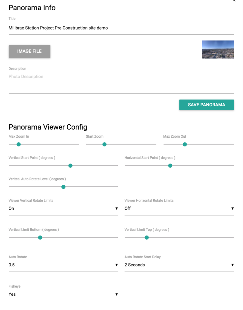
| Depending on what /drone/app/program (settings) you are using to stitch your panos, it can be slightly different. (These examples were done with Mavic) DronePan/Litchi app (you will need to add sky in photoshop)see ex: [redacted at client request] "Spherical" setting in DJI GO 4 app (Photo) you will have enough sky in the pano to adjust see ex: https://36ty.us/AfHmeU Attached are my setting for a pano with the Mavic using the DJI GO 4 app with no added sky. This is the easiest and most time efficient; however you will need to tweak your adjustments based on the POI  Here are some pano sky files: https://www.dropbox.com/sh/jobfnh5y4w6omkh/AAAkw8uRasDscPCjNRlBi2iPa?dl=0 |
||
| Post 3 • IP flag post | ||

Missoula, MT |
rpetersn private msg quote post Address this user | |
| @alsangio - Thank you for your message. We've received your support request as well. Thanks also to @Bycha for your notes. There is a bit of a learning curve to creating panorama images and we're here to provide assistance whenever possible. While there are many different terms that can be used to describe panorama images, there is only one that you need to be concerned with: Equirectangular Panorama (aka "Spherical Panormama" This flavor of "panorama" is exactly twice as wide as it is tall (always) and includes all of the information for full 360 viewing, including the "zenith" (very top) and the "nadir" (very bottom. [i]If the image you are trying to upload into ThreeSixty Tours is anything other than 2x it's width, the results will look funky, to say the least.[i] The challenge is that when you are capturing a scene with a drone, you need to stitch together many images to create this type of image, each one overlapping the next a bit. Drone-based applications (like the Litchi app) do a great job of automating this capture process. Other (desktop) applications do a great job of stitching these images together, so long as you've selected the appropriate "type" of panorama (i.e "Equirectangular/Spherical Panorama" One other note to consider (as @Bycha notes) is that if your drone has a camera mounted beneath (as most do) there's no easy way to capture the sky directly above the drone ("zenith" Assuming your drone does not have the ability to capture the sky above, the easiest solutions (in our opinion) is to either: 1) Photoshop in a new sky, using the (fantastic) sky examples provided by @Bycha 2) Create a "zenith cover" with your logo/etc that can be placed at the "top" of your image to cover up the area with missing sky. 3) Use settings within ThreeSixty tours to prevent panning up to the "zenith"...noting (however) that you still need the image that you upload to be correctly sized, even if there is no sky content at the very top. I hope this (very brief) overview is helpful and we're here to help answer any questions! Cheers...Ross |
||
| Post 4 • IP flag post | ||

|
alsangio private msg quote post Address this user | |
| Thanks all for your responses! Really helped a lot! | ||
| Post 5 • IP flag post | ||
|
|
Faga private msg quote post Address this user | |
| @rpetersn Heyy Ross, Is it possible to use a 2D panorama (taken by DJI Spark, with DJI's panorama option in the app) as our base picture? Thanks, |
||
| Post 6 • IP flag post | ||

|
alsangio private msg quote post Address this user | |
| @rpetersn Have you ever considered enabling the ability to use as base image a flat image? Like an orthomosaic? And build the tour around that? |
||
| Post 7 • IP flag post | ||

|
Briski2208 private msg quote post Address this user | |
| You can also capture zenith photos after your drone has landed by simply pointing the AC camera to the sky & taking a couple prior to stitching. | ||
| Post 8 • IP flag post | ||

Missoula, MT |
rpetersn private msg quote post Address this user | |
| Hi @alsangio & @Faga & thanks for the notes. Yes, in fact, we're extremely close to releasing this as a new feature to ThreeSixty Tours. We thought it would be turned on by now, but the wildfire situation in California has one of our developers scrambling a bit and we needed to push this release a week or so. If either of you would like to use the tools (currently in Beta) right now, please let us know and we can enable this for you. We're super excited to release these new options as soon as possible....just a few remaining bugs to squash. @Briski2208 - Good point about capturing a separate zenith image after the drone has landed....that's a great tip! |
||
| Post 9 • IP flag post | ||

|
alsangio private msg quote post Address this user | |
| @rpetersn Wow ! This is amazing news! Thanks a lot! No worries, I can wait for it to be properly done. |
||
| Post 10 • IP flag post | ||
 WGAN Forum WGAN ForumFounder and Advisor Atlanta, Georgia |
DanSmigrod private msg quote post Address this user | |
| @rpetersn Hope your California-based developer is okay. Dan |
||
| Post 11 • IP flag post | ||

|
alsangio private msg quote post Address this user | |
Quote:Originally Posted by rpetersn Hey @rpetersn Any development on this new feature? Really looking forward on it! Hope your developers are doing ok after the fire. |
||
| Post 12 • IP flag post | ||

Missoula, MT |
rpetersn private msg quote post Address this user | |
| Hi @alsangio - Thanks for chiming back in here. Yes, we've released the 2D Image feature as part of ThreeSixty Tours. It is ready for you to check out! Cheers. |
||
| Post 13 • IP flag post | ||

|
alsangio private msg quote post Address this user | |
| @rpetersn Wow! Thank you very much! I'll go check it out right away! haha! |
||
| Post 14 • IP flag post | ||
Pages:
1This topic is archived. Start new topic?


