New MP-ad & landing page for Pointcloud3193
Pages:
1

|
mori private msg quote post Address this user | |
| Looks like MP makes currently ADs for AEC & BIM offering 20% discount: FILL OUT THE FORM TO GET 20% OFF YOUR PRO 3D CAMERA PURCHASE The landingpage: http://try.matterport.com/inexpensive-3d-scanning-for-aec Just got these banners redirecting to this landing page mentioned above.   The issue and my opinion is: their 3D data is not at all usable for AEC or BIM. Or did I miss something? In my experiences 3D pointcloud data for AEC & BIM must have an accuracy of 5mm. Here some examples & example data. PS: AEC & BIM should be available Tags. |
||
| Post 1 • IP flag post | ||
 WGAN Basic WGAN BasicMember New Brighton, PA |
frstbubble private msg quote post Address this user | |
| It says 1% accuracy when using point clouds. Previously you would download mesh. So they might be saying the point cloud is more accurate. | ||
| Post 2 • IP flag post | ||

Putten NLD |
DannyBasting private msg quote post Address this user | |
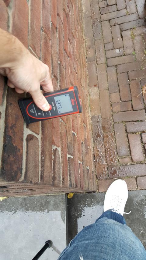
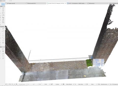
| This was the main reason for me to invest in a Matterport camera. The Pointcloud-data is accurate enough for me. Since I was a little sceptical about its preformance outdoors, I took some laser measurements as well for comparison. I was pleasently supprised.. See images below. Close enough in my opinion!   For my next scan I'll take some inside measurements for comparison as well. Also.. great suggestion about adding those tags. |
||
| Post 3 • IP flag post | ||

Putten NLD |
DannyBasting private msg quote post Address this user | |
| Uploaded image seems to be compressed to much in order to read the measurement. Laser measurement: 5373mm Pointcloud: 5379mm |
||
| Post 4 • IP flag post | ||

|
Marcel private msg quote post Address this user | |
| @DannyBasting what software are you using to view the point cloud and take measurements? I'm looking for a web hosted application to allow my clients to view point files. I want to offer more BIM solutions but am worried about the accuracy. I've gotten quotes for FARO laser scanners but OMG they start from $50K US. The other option is to manually laser measure but I only do commercial with floor plates sometimes up to 2500 sqm. |
||
| Post 5 • IP flag post | ||

Putten NLD |
DannyBasting private msg quote post Address this user | |
| @Marcel I use ArchiCad. See my thread here for more info. |
||
| Post 6 • IP flag post | ||

|
grmngrl private msg quote post Address this user | |
| @DannyBasting how much can you charge a company for this service? I bet it is expensive to use the program. | ||
| Post 7 • IP flag post | ||

Putten NLD |
DannyBasting private msg quote post Address this user | |
| @grmngrl I make an estimate for each individual project. Scanning a property and using the pointcloud-data allowed me to be faster and more accurate compared to the "traditional" workflow, where I had to sketch a floor plan on site and writing down all measurements I took. Thus making me more competitive. Both "measuring" and creating CAD files is faster this way. People are more then happy to pay for a scan if it results in a cheaper "total solution" in the end while undergoing a renovation. |
||
| Post 8 • IP flag post | ||
|
|
ron0987 private msg quote post Address this user | |
| @DannyBasting, I just saw this and was glad you tried it for yourself. All the articles I read showed that short term horizontal measurements (on an x, y axis)were close like you have shown. Where they showed a major difference was the vertical(z axis) distance which showed more of a difference. Were you able to check that and verify that? The z axis making the big difference which caused the major error over long distances. Ron |
||
| Post 9 • IP flag post | ||

Putten NLD |
DannyBasting private msg quote post Address this user | |
| @ron0987 No I haven't since I wasn't anticipating issues indoors. And I didn't care about the Z-axis outside for the project I was working on. But I'll check it next time I'll go scanning. Do you mind sharing the article(s) you mentioned? Danny |
||
| Post 10 • IP flag post | ||
|
|
ron0987 private msg quote post Address this user | |
| @DannyBasting This article was posted by @Grant a few months ago, I have not had a chance to compare Matterport with Faro but that is on the agenda in the next month or two. clickable text Ron |
||
| Post 11 • IP flag post | ||
 iGUIDE iGUIDEFounder/CEO Kitchener, Canada |
Alex_iGuide private msg quote post Address this user | |
| PrimeSense's sensor used in MP camera, the same technology as in Kinect 1, is a triangulation-based sensor with the baseline distance (between the light projector and the measuring camera) of only about 7cm or 3". Range measurement error in a triangulation sensor is inversely proportional to the baseline distance (longer baseline is better) and directly proportional to the *square* of the measured range. The relative range measurement error, i.e. range error divided by the range and typically expressed in %, grows linearly with range. So, when saying that measurement error is 1%, that information is only useful when coupled with the range at which it is observed. If the measurement error is 1% at 6ft, it will be 3% at 18ft or 6.5". When measuring a room with a triangulation sensor, better results are obtained when standing in the middle of the room (max range is half the room length) rather than when standing at one end of the room (max range is room length). That also explains why MP errors are larger when measuring up. Triangulation sensor accuracy relies heavily on the geometry of the sensor being very stable. If baseline distance changes (unlikely) or the angle between the light projector axis and the measuring camera axis changes (more likely as the sensor board can flex), the measurement error can increase quite bit. The sensor geometry can be temporarily or permanently affected by temperature swings or mechanical shock to the camera. As the camera heats up, its measurement accuracy will degrade, more so in hot environments. Time-of-flight sensors, such as used in Kinect 2 or iGuide IMS-5 camera, have the measurement error that is practically independent of the range. With that, the relative range error (in %) actually decreases with distance. The measurement error in time-of-flight sensors is also not affected by sensor geometry. |
||
| Post 12 • IP flag post | ||
|
|
ron0987 private msg quote post Address this user | |
| Alex, since you seem to know what your talking about and have way more knowledge of this than I do, I have a technical question with what you just stated, does the error factor go down with extra scans with Matterport in the same room. I know that with scanners the error factor can be decreased with additional scans. So any ideas sense I do not know how the software computes the final mesh. So my interest would be if I am looking for a point cloud as final product which is a conversion from the OBJ file to be as accurate as possible. Ron |
||
| Post 13 • IP flag post | ||
|
|
ron0987 private msg quote post Address this user | |
| @Alex_iGuide, Please remember Christmas/Black Friday specials are just around the corner, I want to be in line for the first special you may have. Ron |
||
| Post 14 • IP flag post | ||
 iGUIDE iGUIDEFounder/CEO Kitchener, Canada |
Alex_iGuide private msg quote post Address this user | |
| With more scans you collect more data and, as a minimum, that data will result in a denser point cloud and finer mesh. That will increase computation time and storage requirements, so MP must draw a line somewhere for practical reasons and may limit how dense the point cloud is and how fine the mesh is that they store and make available for download. If you leap-frog along the wall with more scans, the overall room length error will be smaller compared to fewer scans spaced further apart. If you are looking for dense point cloud, then Leica BLK360 is the tool for the job. If you run business numbers on it based on your usage scenarios you may find the $16k price for it will pay off quite fast. |
||
| Post 15 • IP flag post | ||
Pages:
1This topic is archived. Start new topic?


