


Elevations from Matterport?20683
Pages:
1|
Survey, LLC Olathe, Kansas |
rhelling private msg quote post Address this user | |
| I know this is off topic from the typical “floor plan” discussion. But I was wondering if anyone has had luck scanning the side of a building and creating and elevation document in CAD. I know Matterport is capable of producing a floor plan. I was just curious if anyone has heard any technologies that will produce an elevation. | ||
| Post 1 • IP flag post | ||
 Owner, Owner,Managing Editor and Publisher of WGAN Forum and WGAN-TV Podcast Fairfield, California |
TomSparks private msg quote post Address this user | |
| @rhelling Hi, I've scanned several projects using the Pro3 and have had elevations made. a link to some samples can be found here. Tom Sparks Scan Your Space (a Division of Sparks Media Group) Founder and CEO Tom Sparks | www.ScanYourSpace.com | www.SparksMediaGroup.com |
||
| Post 2 • IP flag post | ||
|
|
ron0987 private msg quote post Address this user | |
| @rhelling off topic definitely not just another use for exterior use I am glad @TomSparks had some samples to share I cannot share the two projects I scanned last year because they are currently in the construction phase and the architect has me restricted to not sharing just yet. | ||
| Post 3 • IP flag post | ||

|
DigitalReplica3D private msg quote post Address this user | |
| I purchase the MatterPak. With that 3D file. Baezeni was able to create a CAD file with elevations. The use case was a 6,500 sq ft home with interior demod to the studs. A interior designer needed the window elevations. https://baezeni.com/ Best, |
||
| Post 4 • IP flag post | ||
|
Survey, LLC Olathe, Kansas |
rhelling private msg quote post Address this user | |
| @scanyourspace I've got a commercial retail project with a crazy front facade. The tenant is asking for an elevation. Normally we would use a laser and just try to hand draw with measurements from the laser. How are you "creating" the elevation from a Matterport scan? Are you ordering the BIM from Matterport and creating it from there? I haven't seen any product from Matterport that could be ordered related to 'elevations'. Thoughts? |
||
| Post 5 • IP flag post | ||
|
Owner, Managing Editor and Publisher of WGAN Forum and WGAN-TV Podcast Fairfield, California |
TomSparks private msg quote post Address this user | |
| @rhelling I got the .e57 from the scan then had it converted in to revit files by my editing team. They drew the elevations. what level of detail does the client need? pro3 is ok but if they want very specific measurements (accurate, detailed) you may want to consider something like the blk360 g2, or the rtc360. tom |
||
| Post 6 • IP flag post | ||
|
|
DigitalReplica3D private msg quote post Address this user | |
| Note that I’ve had success with using the files in MatterPak. MatterPak is half the cost of an E57. With MP reserving the right to delete the E57 after 3 years do to the massive file size. The BLK 360 has much better accuracy however the camera is over $27,000. 95% of AEC work can be accomplished with the Pro3 per Matterport’s studies.  |
||
| Post 7 • IP flag post | ||
|
|
DigitalReplica3D private msg quote post Address this user | |
| I agree with @scanyourspace. You’ll need to know your clients needs regarding level of detail (LOD) Pro 3 claims an LOD-200 |
||
| Post 8 • IP flag post | ||
|
Survey, LLC Olathe, Kansas |
rhelling private msg quote post Address this user | |
| Thanks all. BLK 360 is out. Not in the budget for how it would be used. Pro3 works best for our current deliverables and if we could couple it with a MatterPak (...like @DigitalReplica3D) I think that might work. I might test a MatterPak on the exterior of my house or an easy commercial project nearby. |
||
| Post 9 • IP flag post | ||
|
|
DigitalReplica3D private msg quote post Address this user | |
| @rhelling Looking forward to hearing about the results. Please keep us posted. | ||
| Post 10 • IP flag post | ||
|
|
ron0987 private msg quote post Address this user | |
| @rhelling You should get to know some of the company's that service the survey equipment in your area. I would look for one of the larger ones, the one I deal with always takes in trades services them and then puts them out at a discounted rate. They are always running specials. You just need to look and then you have hands on and if there is an issue you can also get advice. I know that last year the company near me had a Blk360 at a good price but, I definitely would ask around to a few of them to see what they have. | ||
| Post 11 • IP flag post | ||
|
Survey, LLC Olathe, Kansas |
rhelling private msg quote post Address this user | |
| @ron0987 good advice. also...I scanned a small office space yesterday with a Pro3 and got a MatterPak. I scanned about 20' out the front of the building so I could get a front elevation. Honestly, I'm kinda impressed - and surprised we've never done that before. The level of detail is good enough to put some general building elevations together. I'll post my results when I get it all finalized. |
||
| Post 12 • IP flag post | ||
|
|
DigitalReplica3D private msg quote post Address this user | |
| @rhelling. Great to hear! | ||
| Post 13 • IP flag post | ||
|
Survey, LLC Olathe, Kansas |
rhelling private msg quote post Address this user | |
| Here are the results. The level of detail was fine for the purpose. I thought it worked pretty well. 1) Matterport Model 2) MatterPak - Imported the model into Revit | Elevation View 3) Used as a guide to help draft the front elevation. 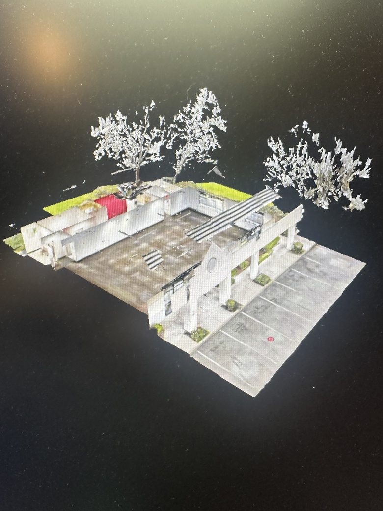 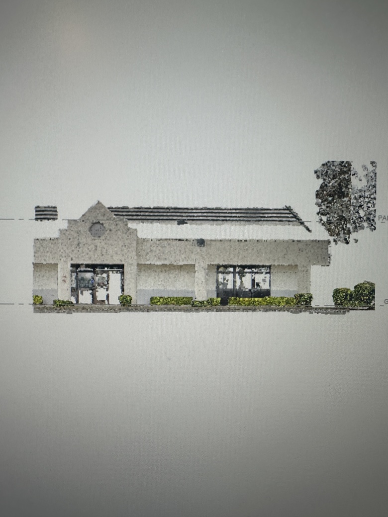 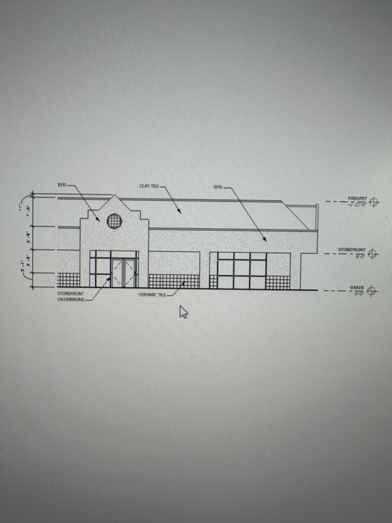 |
||
| Post 14 • IP flag post | ||
|
|
DigitalReplica3D private msg quote post Address this user | |
| @rhelling Happy it worked out for you! | ||
| Post 15 • IP flag post | ||
|
|
ron0987 private msg quote post Address this user | |
| @rhelling That look good, good job, that's what I have been providing for basic work for a few contractors to give them conceptual ideas prior to going to architects. | ||
| Post 16 • IP flag post | ||
|
|
DigitalReplica3D private msg quote post Address this user | |
| @rhelling I’m curious of your Pro 3’s speed to capture the elevations. Was it set at regular, medium or high density scanning? I don’t have the software to view the MatterPak files. I’m interested in how the different densities affect the file details. Best, Charlie Grimm |
||
| Post 17 • IP flag post | ||
|
Survey, LLC Olathe, Kansas |
rhelling private msg quote post Address this user | |
| @DigitalReplica3D We use AutoDesk Revit to import the MatterPak and (.dwg) documents. We haven't had much luck with Matterport's BIM products, so we create the architectural models ourselves. That being said, we always have our Pro3 set to 'standard' and for the example above - it just took a few minutes to make sure we included 5-6 scan points on the exterior. The density question is a good one. I have another project that requires elevations next week. I'll test out the different densities and see how it effects things. Randall |
||
| Post 18 • IP flag post | ||
Pages:
1This topic is archived. Start new topic?