


More sweeping scanners Eagle/Eagle Max20590
 WGAN Fan WGAN FanClub Member Queensland, Australia |
Wingman private msg quote post Address this user | |
| Spotted on Facebook a few days ago before they announced the price today. To be honest looks too cheap to be true. Based on what I see it comes with Mid-360 lidar by Livox(about US$780) and four 48mp sensors(about $160) So these two parts alone making it almost US$900 in parts cost but still plenty of other parts that cost something and the whole unit(Max version) is US$2650 with 50% discount. The company is known for objects scanning devices but reviews for them are mixed up from "it is [redacted]" to "it is good"    They have videos on their website using it indoor and outdoor. I am not sure if Dan wants the link here but you can always google and find them. It creates both point cloud and Gaussian splats. I bet if you want splats you want Max version as you can do it faster combing videos from all sides. I do not know anything about it for now. If it were an existing product with some good reviews I would buy Max for US$2700 Happy New Year to everyone! |
||
| Post 1 • IP flag post | ||
 WGAN Fan WGAN FanCLUB Member Coeur d'Alene, Idaho |
lilnitsch private msg quote post Address this user | |
| I have seen this but, haven't looked too far into it ~ I have also seen it promoted flying on a drone | ||
| Post 2 • IP flag post | ||
 WGAN WGANStandard Member Osaka, Japan |
Meidansha private msg quote post Address this user | |
| Wow, 3DGS with LiDAR for just 2200 USD. Yeah, it does feel too good to be true. But I guess the industry is just hard to break into and only very situational uses like real estate or virtual tours at that level of accuracy (2cm). However I can think of some interesting use cases. I wonder ifmy clients would be willing to pay for that edge? |
||
| Post 3 • IP flag post | ||
|
WGAN Standard Member Osaka, Japan |
Meidansha private msg quote post Address this user | |
| Does "150pcs" mean that you have to assemble it yourself? | ||
| Post 4 • IP flag post | ||
|
WGAN Fan Club Member Queensland, Australia |
Wingman private msg quote post Address this user | |
Quote:Originally Posted by Meidansha :-) I think they refer to how many units can be funded through their offer on Kickstarter platform. |
||
| Post 5 • IP flag post | ||
|
WGAN Standard Member Osaka, Japan |
Meidansha private msg quote post Address this user | |
| I see. I couldn’t find the Kickstarter page. Could you send me a link? |
||
| Post 6 • IP flag post | ||
|
WGAN Fan Club Member Queensland, Australia |
Wingman private msg quote post Address this user | |
Quote:Originally Posted by Meidansha I could not find it either. May be they just got ahead of themselves with advertising these two devices before they actually created crowdfunding campaign. If they publish a link to their Kickstarter page I will add it to this thread. |
||
| Post 7 • IP flag post | ||
|
WGAN Fan Club Member Queensland, Australia |
Wingman private msg quote post Address this user | |
| Found this but it still does not have a date Quote: Originally Posted by 3dprintingindustry.com The whole interview is here |
||
| Post 8 • IP flag post | ||
|
WGAN Fan Club Member Queensland, Australia |
Wingman private msg quote post Address this user | |
| I have just fished this example from a Facebook group related to Eagle Scanner. The guy who provided it has said he is an early tester and he is going to write a review on it around 11th of February You can download a sample data from his google drive Here is what it looks like in CloudCompare for over 11M points. The data is not colorized with real texture so colors you see below are just high contrast or other colorizations method provided by CloudCompare. I will stay interested in this product until I am satisfied with all I see and buy it or something bad I see that pulls me out of being interested in it. I believe it is data collected from scanning a monument. There should be a youtube video showing how it has been done. Density wise, it is not too much dense if you get closer to the monument data but in the video the guy never came close and was scanning it from a few meters. If it is mid-360 is being used in this scanner it should collect 100000 data points per second.   |
||
| Post 9 • IP flag post | ||
|
|
ron0987 private msg quote post Address this user | |
| @Wingman I still keep seeing the posts on Facebook, you would think if we were getting that close they would be posting a release date. | ||
| Post 10 • IP flag post | ||
|
WGAN Fan Club Member Queensland, Australia |
Wingman private msg quote post Address this user | |
Quote:Originally Posted by ron0987 Honestly I cannot say. If it was a new company that would be suspicious. However they make and sell 3D scanners for small objects and have plenty of models in this space. So for now I do not think it is too suspicious. |
||
| Post 11 • IP flag post | ||
|
WGAN Fan Club Member Queensland, Australia |
Wingman private msg quote post Address this user | |
| Just a reminder to everybody that 11.02.25 is when they start selling it. So less than 24 hours left. Only 500 units at 50% discount. So far I determine to buy Eagle Max. They accept PayPal so I think it makes it almost risk free. They have added a few samples with point cloud data to their product page https://store.3dmakerpro.com/pages/eagle-lidar-3d-scanner |
||
| Post 12 • IP flag post | ||
|
WGAN Fan Club Member Queensland, Australia |
Wingman private msg quote post Address this user | |
| I have placed an order for Max model plus rtk module. And then discovered a 3D tour coming from this scanner. Try this People on their Facebook group where asking before how it's compared to Matterport and I thought it was not comparable at all. I actually stand corrected now. I love it and I believe it comes as a competitor to Matterport. And imagine it all could be done in seconds/minutes. See the screenshot of the first 3D tour on their page. There is more than just one and to see them scroll the page to the right. 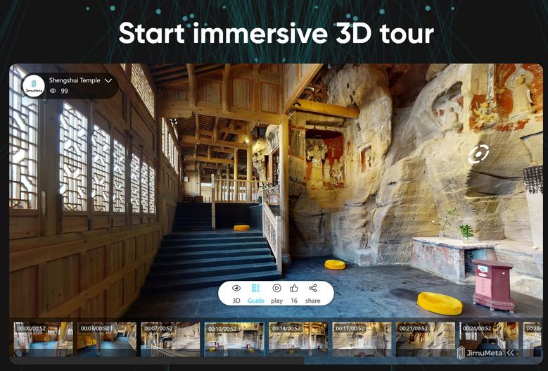 |
||
| Post 13 • IP flag post | ||
|
WGAN Fan Club Member Queensland, Australia |
Wingman private msg quote post Address this user | |
| Oops, found a long promised video review for the scanner with 80 EURO discount code for purchasing the scanner. So I have missed on the discount but that's fine, may be you can use it or it can be used later when purchasing accessories. The discount code is in the video description |
||
| Post 14 • IP flag post | ||
|
WGAN Standard Member Osaka, Japan |
Meidansha private msg quote post Address this user | |
| @Wingman Thanks for the discount tip! I just matched your order. I have no idea how to connect the RTK module but perhaps it will help to improve that accuracy? There goes my development budget for this year… |
||
| Post 15 • IP flag post | ||
|
WGAN Fan Club Member Queensland, Australia |
Wingman private msg quote post Address this user | |
Quote:Originally Posted by Meidansha no worries, I am glad it at least helped you to get it cheaper. As for RTK, I have all these questions too because of my previous experience with another RTK module. Usually they are sold in pairs and you set one as a base and another as a rover and make them communicate. It is the base that sends all corrections to the rover. There is another valid method where you use free servers usually provided by a government to get corrections. However you need to enter details like your login/password and URL to access data to make it working. May be there are settings for RTK in the scanner to do it all. It is also possible that they just send you a GNNS receiver with multiple constellations to choose from. If you use 2-3 at a time it can be more accurate than just from one(Say GPS) but it is not close to 2cm RTK can usually deliver. We will see. |
||
| Post 16 • IP flag post | ||
|
|
ron0987 private msg quote post Address this user | |
| My only concern is 10 models are $10 a month and $100 models are $80.99 a month. I think they look good, but if you just ran the model thru for data no issue, but if you created the model for immersive walk thru then your hosting fee might be a little steep unless there was a way to white label host it. But definitely a 3dvista model creator. Do you need their software to process the models to get an output file, I asked that question from them and never got an answer. | ||
| Post 17 • IP flag post | ||
|
WGAN Fan Club Member Queensland, Australia |
Wingman private msg quote post Address this user | |
| Does it show you subscription cost for their tours? Mine is shown as ?? instead of values. It could be that they set prices in USD for USA so you can see them but when they track me as AU user by IP their currency conversion fails(see attached picture) I believe you need their software to extract lidar, image and location data from ROS bags. I am assuming it because I have never worked under ROS but have seen everywhere that it is using bags to store data. If the video review above you can see that there are the files with bags extension that are imported into their software. I cannot say if there any 3rd party app that can get data from a bag file. However it seems it is only critical to get that data using their app and once it is out and in the app you can save it in many accepted by other programs formats. There is a little argument in their group if the first tour has been actually captured by Eagle scanner. It is hard to say so my guess we al have to wait and test it ourselves. However they kind of claim photo quality to be from 12K to 20K so if that's true I believe it is made by Eagle scanner driven through a space sitting on some kind of a rover.  |
||
| Post 18 • IP flag post | ||
|
WGAN Fan Club Member Queensland, Australia |
Wingman private msg quote post Address this user | |
ok, one group user just spotted a shadow of a Matterport Pro2 in their 3D tour. Not cool starting a new product with lies. 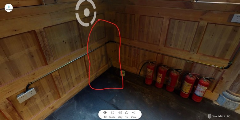 BTW, it has never happened to me before and I have had 10000s transaction through PayPal. PayPal says I paid from my bank account, 3DMakerPro says they have received my order and the payment. However nothing has been taken from my bank account at all, and nothing sitting on it as pending like this transaction has never happened. |
||
| Post 19 • IP flag post | ||
|
|
ron0987 private msg quote post Address this user | |
| @Wingman the subscription cost are as listed on the webpage which are steep, but I found that that the processing software is included with each order. But not good about the Matterport shadow. | ||
| Post 20 • IP flag post | ||
|
WGAN Standard Member Osaka, Japan |
Meidansha private msg quote post Address this user | |
| @wingman on the RTK point, they just updated the landing page to include info on the accessories. Here is what is listed on the RTK module (the short of it is you need a base station). “ RTK (Real Time Kinematic) is a dynamic measurement technology that utilizes carrier phase observation for real-time differential GPS (RTDGPS). It consists of a base station receiver, a data link, and a rover receiver, typically using dual-frequency signals from satellite systems like GPS, GLONASS, Galileo, and Compass. Our RTK Antenna & Signal Module enhances positioning accuracy through real-time differential correction, achieving absolute accuracy of point clouds within 1-3 cm. This accessory requires a base station and can be calibrated using wireless communication on the L1 channel (1575.42 MHz) and the L2 channel (1227.60 MHz).” |
||
| Post 21 • IP flag post | ||
|
WGAN Standard Member Osaka, Japan |
Meidansha private msg quote post Address this user | |
| @Ron0987 I’m not too worried about the “sharing” web server. I have got 3D vista worked out now and I have already managed to make something Matterport-like with a Faro point cloud converted to mesh and the panos out of the Faro as sweeps. With this I should be able to download all the components I need to give a client what I usually provide and give me the option to offer 3DGS as an option too. The only issue is bigger spaces. Lots of scans made in under 5 minutes will mean a lot of stitching and a lot of subsampling point clouds/ compressing mesh. |
||
| Post 22 • IP flag post | ||
|
|
ron0987 private msg quote post Address this user | |
| @Meidansha no I agree I am looking at it to create models not the virtual tour aspect even though the virtual tours are very nice. | ||
| Post 23 • IP flag post | ||
|
WGAN Standard Member Osaka, Japan |
Meidansha private msg quote post Address this user | |
| @ron0987 It looks like it is scheduled to arrive in 6 weeks, so I should probably be able too post an example in April. | ||
| Post 24 • IP flag post | ||
|
|
ron0987 private msg quote post Address this user | |
| I just watched the video of first hands on review and for now I am not going to get ii. Nice in theory but had enough issues I will wait good price but for now I will just stay with what I am using. They may work these issues out and they are not major but I was saw enough it would not work for me. | ||
| Post 25 • IP flag post | ||
|
|
ron0987 private msg quote post Address this user | |
| @Meidansha unfortunately it looks like they admitted to the Matterport mishap on Facebook, not sure it’s a very convoluted posting and only one from company at the time I read it. Plus dispute on tech data. Not sure what to think about it at this point. I wish they would come forward with good data, I am trying to follow that Facebook post it’s all over the place. Does anyone have any other good info? | ||
| Post 26 • IP flag post | ||
|
WGAN Fan Club Member Queensland, Australia |
Wingman private msg quote post Address this user | |
Quote:Originally Posted by Meidansha I do not know much about L1 or L2. The way I was using mine was: After I could not use my RTK set due to how internet connections work now I simply created an account for government online services supplying corrections, got a url from them and used NTRIP android app to connect to the rover using my login details from the government service to apply correction in real time. I could get 2cm accuracy shown in the app but I had never tested with a real place or data and was just driving around with it working. Without corrections the app showed accuracy from 0.3m to 3m. Back to Eagle: There is extra information in one thread about how you can use their so called RTK module. Here is a link to the whole thread. What I see are two options: 1) post processing all GNNS data. I have forgotten what it is called but it is a valid and known method. Basically you collect all data from a rover module(their RTK system) while some stationary base near by collecting GNSS data for corrections. So you mix them together to correct rover position after it is all done https://www.facebook.com/groups/920361733495397/posts/958530949678475/ 2) There is a NTRIP Client app for Android. See the link from the developer website below but you can also find it on Google Play market. That is the app I used and mentioned at the beginning of my post. http://lefebure.com/software/ntripclient/ I am sorry for posting that link to "3D tours" done with Eagle which was not the case at all. To their defence it was not posted by 3DMakerPro in their group, it was just a member. I assumed the first tour has been done with the Eagle scanner because their pages mentioned this scanner everywhere. For me the fact that the tour was done with Matterport pro2 still does not put me in any form of regret buying it. I was asking how it can even build a 360 considering sensors position and operator visible at the back. So I did not believe it could before I purchased it. For me 3D part is the more interesting because it can capture big places for point cloud fast. I am happy with its claimed accuracy because I did not expect it could be used for AEC anyway. |
||
| Post 27 • IP flag post | ||
|
WGAN Standard Member Osaka, Japan |
Meidansha private msg quote post Address this user | |
| @Ron0987, Thanks for the update. @Wingman, Thanks for the details on using RTK modules. This is invaulable info for me. I haven't used RTK yet but I am just getting into mapping (at a hobby level) and I thought this would be a good opportunity to try as the module is discounted. I have considered getting a station and module for my Mavic Pro 2 and doing a home conversion but the cost of the station would set me back quite a lot for something that is not going to provide any income for the forseeable future. The Android app or government network option sounds like something worth exploring in early testing. I think I will probably use this device in combination with another 360 camera or even make DSLR 360s to improve the photo element. For small to medium sized scans this could be a good alternative to buying the Matterpak. Anyway, all will be revealed when the device arrives around April. |
||
| Post 28 • IP flag post | ||
|
WGAN Fan Club Member Queensland, Australia |
Wingman private msg quote post Address this user | |
Quote:Originally Posted by Meidansha I am going to update my memory on it so I am more than happy to help everybody. Meanwhile you can try to find NTRIP Broadcasting service in Japan that you can use for correction. I do not remember what is a limit how far away it can be from a place where your rover is. I think mine was 50-70km away and it still worked while normally they would say you will need to be no further than 25km. If anybody needs to know one in Australia I have been using and still have login details to ones run through the following government website. I sent them a request asking for access and almost straight away got a login, a password and a URL with a port number from them. Then it was only a matter entering it in the NTRIP app. The rover I used was connected to the same smartphone through Bluetooth. https://gnss.ga.gov.au/stream |
||
| Post 29 • IP flag post | ||
|
WGAN Fan Club Member Queensland, Australia |
Wingman private msg quote post Address this user | |
| I have started looking how to use Lefebure NTRIP Client app for android in case there is no Bluetooth that can be used to connect Eagle RTK rover to a smartphone running this app. So far I could not get clear instructions on how wi-fi can be used. However when I asked ChatGPT it seems to pick it up from some data found online. Anyway here are the instructions: Quote: Originally Posted by ChatGpt Please note that the link that I have given to Lefebure NTRIP Client is for their windows app. Lefebure NTRIP Client app for Android can be found on Google Play Market. At least there is a way to make it all work with this Eagle scanner RTK module. Do not forget that the phone should be connected to a mobile internet to access NTRIP Broadcaster data for correction. And the scanner can connect to the same phone through Mobile hotspot. |
||
| Post 30 • IP flag post | ||