


I am getting requests for site plans. New Biz opportunity for the Pro3?19110
Pages:
1

|
Sdoughtie private msg quote post Address this user | |
| This is strange, but I just started getting requests for site plans. I did one for a client that I do vacant tenant spaces for. Then other people are calling to have them done. I have to tell them upfront that I am not a licensed civil engineer, and the plans would not be able to used for permitting, but they want me to do them anyway. I know the first client is using it for landscape planning. I'm not sure what the others are planning to do with them. Perhaps this is another market you can expand into if you have a Pro 3. |
||
| Post 1 • IP flag post | ||

|
Gladsmuir private msg quote post Address this user | |
| Hi @Sdoughtie, Are you referring to Schematic Floor Plans or MatterPak? Oliver |
||
| Post 2 • IP flag post | ||
|
|
Mgamache88 private msg quote post Address this user | |
| This is actually the reason I'm looking at getting a pro 3. I have practiced with a 360 camera and drone deploy(when it was free). I want to scan empty lots and places looking for landscaping. Then have a 3d model done to use for estimating and a cad model for machine guided equipment. If you don't mind sharing, how long does it take you to scan an empty lot? Actually? If you're interested I would love to get a matterpak of two examples. An empty site and one with buildings. A point cloud would be awesome too. I want to see what kind of workflow is required to get these into the right format. I'm not the computer wizard this is just part of my business concept. |
||
| Post 3 • IP flag post | ||
|
|
Gladsmuir private msg quote post Address this user | |
| Hi @Sdoughtie, @Mgamache88, You can download samples of the various Matterport Add-ons here https://support.matterport.com/s/article/Matterport-Assets-You-Can-Download?language=en_US A few pointers: Working with point clouds requires expertise that cannot be learned in a short space of time. The sample point clouds cannot be used with the Revit plugin – it needs to be converted first. If you scan inside and outside a building the schematic floor plans will only show the building structure, not any outside areas. Scanning inside and outside does give an indication of the actual thickness of the walls. The number of scans required is site-dependent, but more is required if you are looking at greater detail and accuracy in the MatterPak than if it is just a visual walk-through. The first illustration is the ground floor schematic floor plan from the Matterport Shackleton Museum Project. The accuracy of the dimensions including wall thickness is very good. You can see the thicker walls of the original structure, and the thinner walls of the later additions. The second illustration is the floor plan image from the MatterPak, which includes the exterior up to the trimmed edge of the site. This local media item gives a good overview of the project which will follow the redevelopment of the building into the world’s first National Museum dedicated to the Antarctic explorer Ernest Shackleton. You can read more about the project here: clickable text Oliver 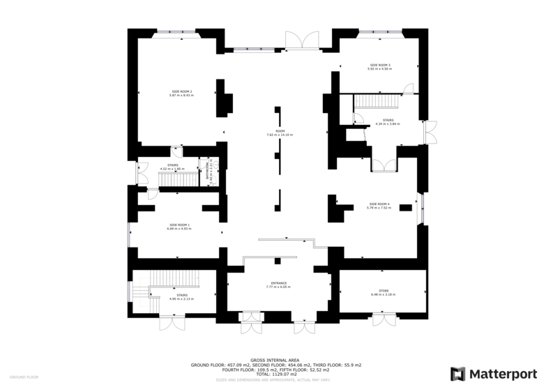 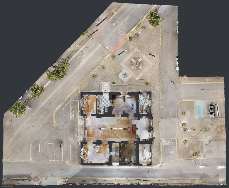 |
||
| Post 4 • IP flag post | ||
 WGAN WGANStandard Member Los Angeles |
Home3D private msg quote post Address this user | |
| My high-end real estate clients often want full site plans for estate homes. We learned years ago how to scan full yards using the Pro 2 at dawn, dusk and overcast days. Of course, now with the Pro 3 we can scan everything any time. Often we back this up with drone shots at 400' looking straight down, or satellite views from Google or Apple Maps. For precision I sometimes research the county assessor's plat maps. All this I send to my go-to provider - Finn Zetterstrom (@Baezeni) at www.Baezeni.com - also known as - www.MP2FP.com Here are examples of their work. Note that you may not see this style on their website, as it's a custom design I requested and they expertly deliver on my jobs. But I'm sure they'd happily deliver this for anyone. Just ask "give me what you do for Home3D.us" 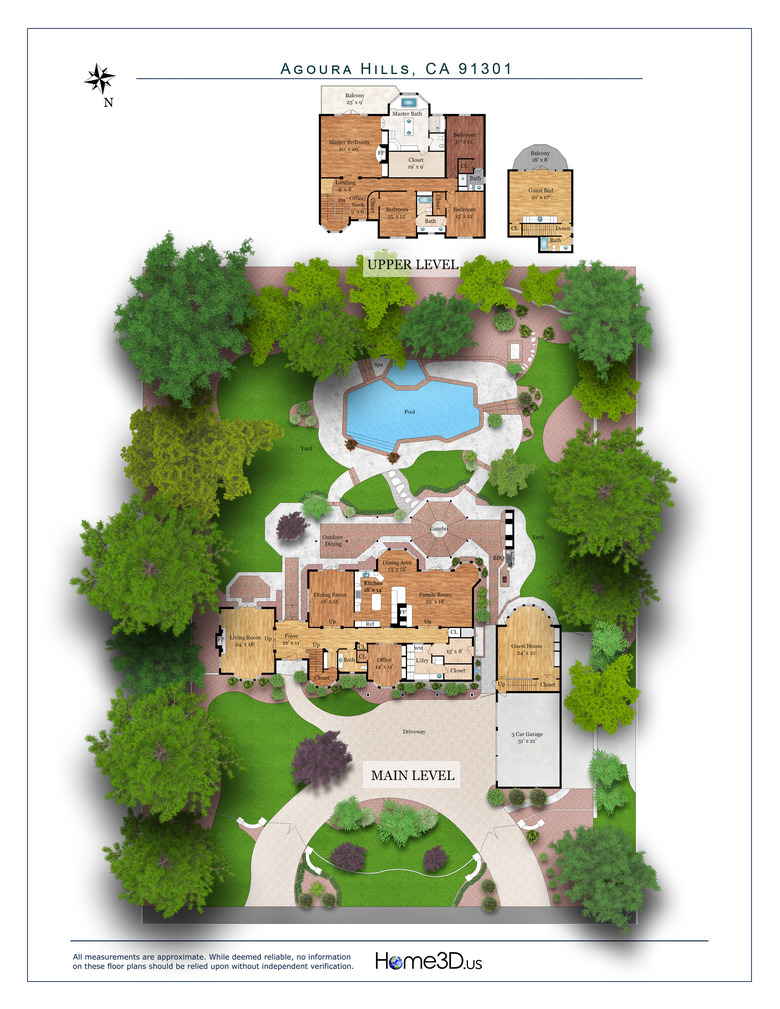 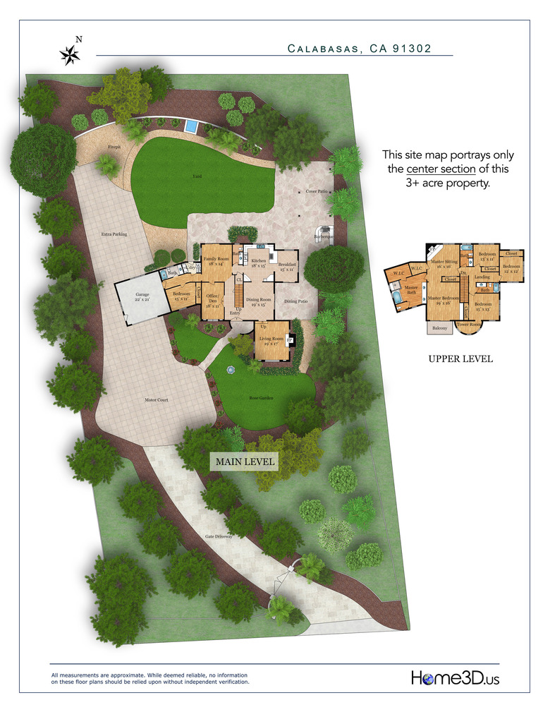 |
||
| Post 5 • IP flag post | ||
 SCAN TO CAD FILE SERVICE SCAN TO CAD FILE SERVICE
|
Baezeni private msg quote post Address this user | |
| @Sdoughtie @Home3D Thank you for the nice and as always inspiring collaboration with Home3d as one of the most forward leaning partners that always want to develop and take new paths to make their clients stand out! When it comes to site-plans and large scale Matterport scans (and other input) our experience as a pointcloud to engineering and sales presentations for clients an all continents, and as a long time WGAN service provider, can be summarized in short by the following points: Depending on what request for siteplans there is some options: 1. If accuracy is not need to be 100% The Pro2 can be used to cover the need for scanning inside, and we can help make the site plan based on the Matterport link and available info on Google map and other info about the surroundings. Some notes and photos or a sketch with some measures will help depending on the need as mentioned. here is examples of the above input: 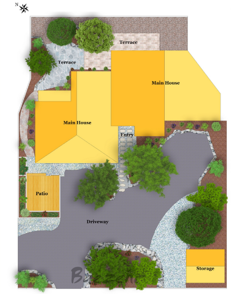 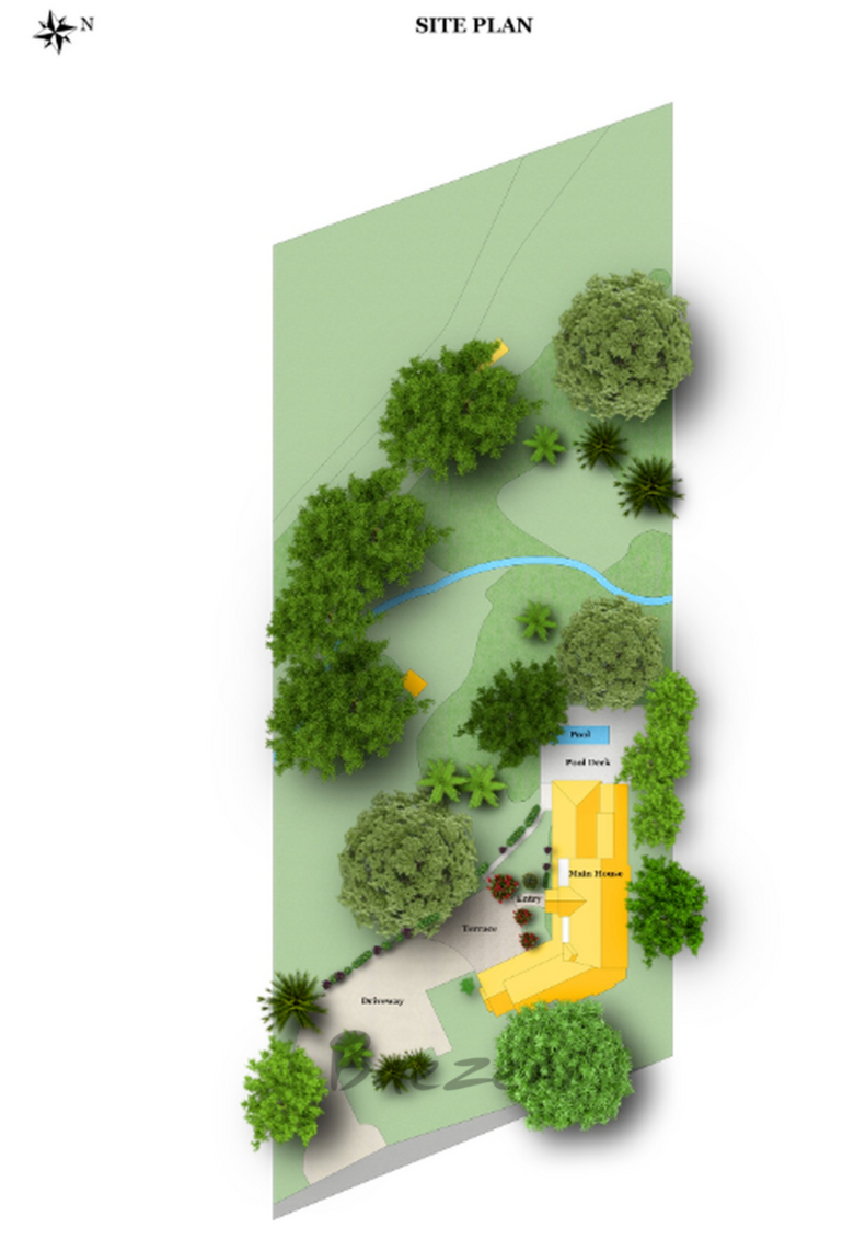 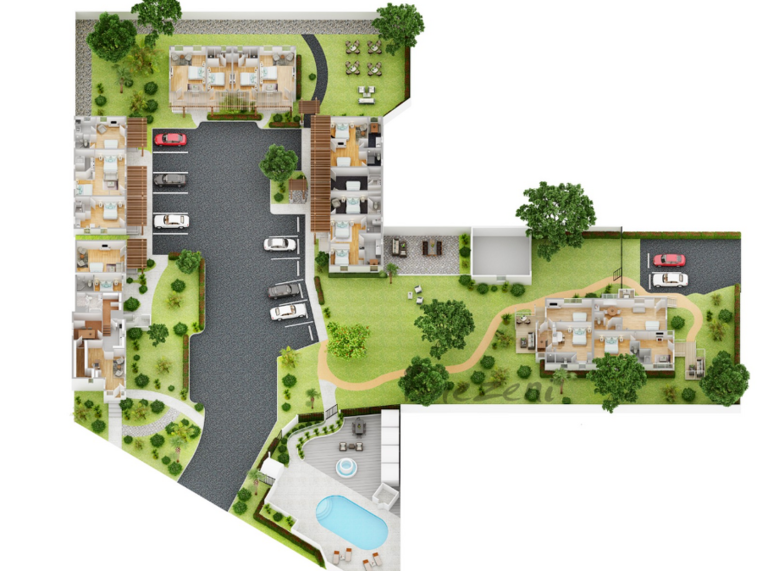 2. If you use the Pro 2 camera outside building We as well can establish a good looking terrain with level curbs but the accuracy will not be 100%. But mostly good emough for sales and preliminary planning. Some examples: 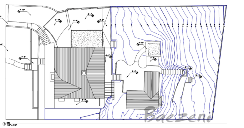 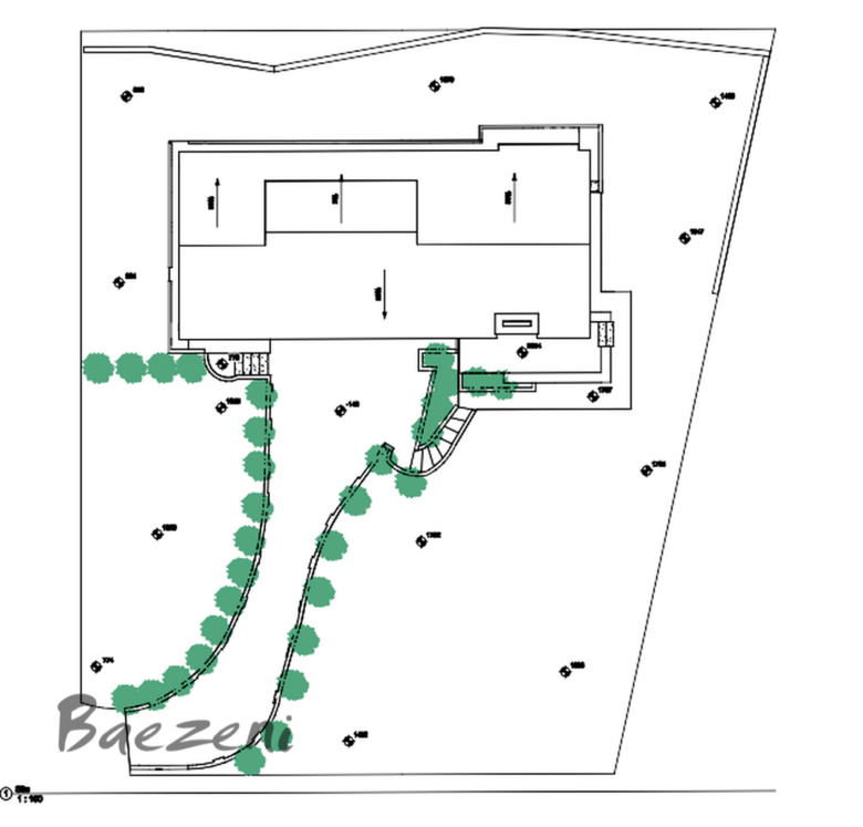 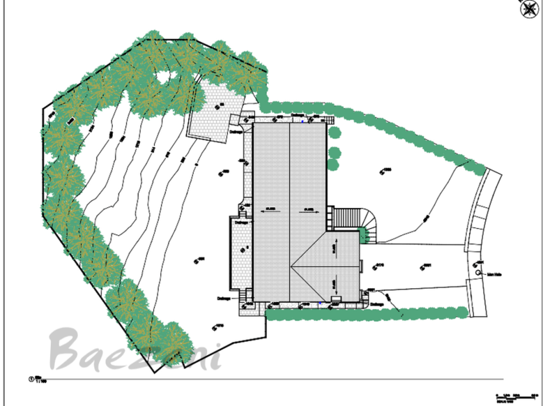 3. Matterport Pro 3 has lidar camera So the same as examples above plus sections and more details can easily be generated, and quality much more accurate because of the good lidar camera. 4. Other methods (with drone scan) If you have large areas or increasing demands in your business for siteplan deliveries And if you want even more accuracy and fast workflow to produce the elevation of siteplans, we recommend using a drone. For example a a Mavic 3 Pro, Phantom 3,4.. for the scan. The elevation data will be more accurate if you choose a drone that have RTK (for correct elevation with Datum). When you use it it will set the datum coordinate, and then use the DJI Terrain software or PIx4D to convert data to Pointcloud that will be well accurate and detailed. If you will save time and money and focus on the collection of data and you deliveries we have 17 years of experience, and will be happy to help and advice at any time. |
||
| Post 6 • IP flag post | ||
Pages:
1This topic is archived. Start new topic?