Seven (7) Acre Indoor/Outdoor Space (Pro3, BLK360, and Pro2)17755
Pages:
1
 IFTI/PROvision IFTI/PROvisionSolutions Director of Operations Concord, California |
everly private msg quote post Address this user | |
| Somewhat more interesting than most of our scans: This one is approximately 7 acres (300k+ SqFt). The building is called The Kendeda Building for Innovative Sustainable Design, and the surrounding grounds are called the Eco-Commons. Both are part of the Georgia Tech campus. It was originally scanned with Pro2 and BLK360, prior to the release of the Pro3. A few months later, about 500 Pro3 scanpoints were added. Altogether, the current version has 1,129 scans. Had the Pro3 been available when we initially scanned, it would have gone much more quickly, and required less scan points. The 500 scans were completed in about 8 hours of scanning time. Needs some editing still, but figured it was worth sharing. Some of the interesting shots are in the highlight reel. Link to scan |
||
| Post 1 • IP flag post | ||

|
Gerhard private msg quote post Address this user | |
| @everly nice job. What is the coverage radius of the Pro3? I am waiting for our units to come, but have a very complex outdoor space to shoot. So need to know if I will do it with our BLK or wait for the Pro3. As the BLK gives me around 4o meters fill in radius and I can move the camera 15 meters between scan points, and still have an mm accurate point cloud for our Revit models. I also see many of the guys shooting with the Pro 3 are not in direct sunlight, why is that? As I see the ones in direct sunlight make these funny-looking artifacts and not smooth transitions very broken looking. Tried opening this on mobile, but does not load, as the tours are just too heavy for mobile with so many scan points. We have been contracted to scan a 494 acres facility, and was wondering with your workflow how long you think this will take. |
||
| Post 2 • IP flag post | ||
 WGAN WGAN3rd Party Service Member Beijing |
JuMP private msg quote post Address this user | |
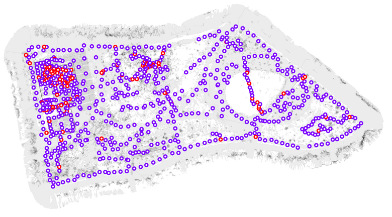
Here is the map of capture points, cover 29461 Sq. Meter |
||
| Post 3 • IP flag post | ||
 WGAN Forum WGAN ForumFounder & WGAN-TV Podcast Host Atlanta, Georgia |
DanSmigrod private msg quote post Address this user | |
| @everly Thank you for sharing this AWESOME/AMAZING Matterport digital twin. I 1. Massive outdoor space 2. people/signs 3. rooftop (not a space that we typically get to walk around) 4. WOW! Interior is beautiful Why were the Pro3 scans added? (Was that the outdoor campus?) That's amazing that you did 500 scans in 8 hours with the Pro3! (Crazy-exciting!) How will Georgia Tech use this Matterport digital twin? Thanks again! Dan |
||
| Post 4 • IP flag post | ||
 WGAN Forum WGAN ForumFounder & WGAN-TV Podcast Host Atlanta, Georgia |
DanSmigrod private msg quote post Address this user | |
| @Gerhard Congrats on the upcoming 494 acres facility project. That's an interesting question about when to use the BLK360 and the Pro3. I could imagine that the BLK360 will enable you to scan faster because of the big distance possible between scans. Does the client need the Level of Detail of the BLK360 scans or is the Pro3 LOD "good enough"? And, I could imagine that if the client cares about the image quality, then the answers will be Pro3? Perhaps your project will be both: BLK360 and Pro3? (using the Pro3 as the active scans and hide the BLK360 scans?) Dan |
||
| Post 5 • IP flag post | ||
 WGAN Forum WGAN ForumFounder & WGAN-TV Podcast Host Atlanta, Georgia |
DanSmigrod private msg quote post Address this user | |
Quote:Originally Posted by JuMP That's a very-cool graphic. What's the "use-case" for: 1. showing the scans 2. showing the size Dan |
||
| Post 6 • IP flag post | ||
 IFTI/PROvision IFTI/PROvisionSolutions Director of Operations Concord, California |
everly private msg quote post Address this user | |
| @Gerhard Good questions - unfortunately, I don't yet have many good answers as I haven't been able to do enough testing. I can confirm that I was able to get Pro3 scans to align with 15 meters between them. It is also hard to do apples-to-apples comparison with the two devices since the BLK360 offers the option of self-registering setups in Cyclone. In any scenario, I think the most accurate result will always come from using BLK360 with Leica Cyclone Field and registering in Cyclone Desktop. Within Matterport ecosystem, my gut feeling is that the Pro3 is more than sufficient for most use cases, but will not be able to match the BLK360 for detailed MEP components, higher ceilings, and certain lighting conditions. As for scanning in direct sunlight - I didn't have any issues with scans in direct sun but I may have placed it in the shade out of habit, where possible. I've not noticed sun artifacts but haven't reviewed too many Pro3 scans yet. I think one potential downfall of being able to spread scans out is that it will hurt the tour experience when there is too big of a jump on screen. That may be a factor in what you're seeing, not sure. 494 acres is a lot and I am hesitate to estimate since I know nothing about the density of the space. What I can tell you is that the first 6 acres of this scan took me approximately 60 hours of scanning when I only had the Pro2 and BLK360. I was able to add the last acre (plus a couple hundred scans throughout the space) in less than 8 hours total with Pro3. It also depends on if the entire 494 acres is to be scanned, or just pathways through the space. In any case, that sounds like a significant (but exciting) undertaking! ---------- @DanSmigrod The Pro3 scans were added because a small portion of the outdoor area was not scanned the first time around (ran out of time). We completed the project with the Pro3 and then worked back to re-scan several areas that had less-than-ideal conditions or scan points the first time around (also replaced some of the BLK360 scans to bring down the overall size). Their main use case is virtual tours but they are working on several other ways to incorporate as well, not sure what all they'll end up using it for. |
||
| Post 7 • IP flag post | ||
Pages:
1This topic is archived. Start new topic?


