SPAR3D: GeoCV taps drones and smartphones to merge indoor and outdoor views10171
Pages:
1
 GeoCV GeoCV
|
Jonathan_GeoCV private msg quote post Address this user | |
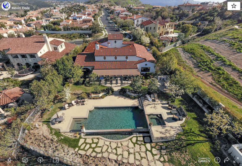
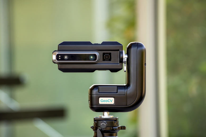
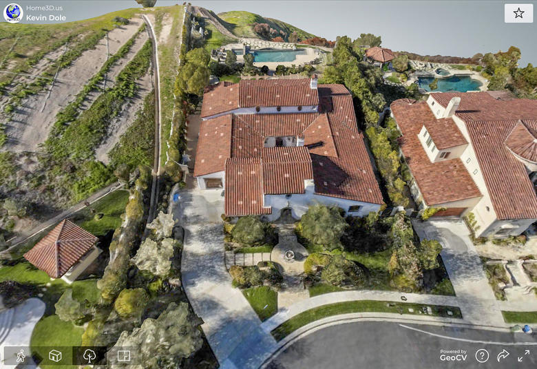
GeoCV taps drones and smartphones to merge indoor and outdoor Source: SPAR3D BY CARLA LAUTER ON SEPTEMBER 24, 2019 TECHNOLOGY: SOFTWARE INDUSTRIES: GEOCV GeoCV is known for their ability to create smooth, realistic 3D+360 tours of existing spaces by using a smartphone depth camera for capture. The GeoCV Cloud automatically stitches together images and 3D measurements into a GeoCV 3D Tour, providing a quick and impressive result with a minimum of scanning effort. Recently, an update to the tour editing software enables users to import and merge captures from drones – opening it potential applications for larger and more complex buildings and properties, both indoor and out.  A GeoCV Rotator equipped with a Samsung Galaxy S8 and Occipital Structure Sensor. GeoCV’s goal is to make the capture process accessible without the need for expensive, specialized equipment. Recently, SPAR 3D wrote about the proliferation of 3D “depth cameras” and Time of Flight sensors that are showing up with increasing frequency in smartphones. Many of the applications discussed were theoretical, but GeoCV, has already realized the real-world use potential. Instead of scanning small objects, GeoCV’s software is designed to capture rooms, landscapes and property. The signature 3D + 360 Tour from GeoCV includes three options for viewing a space. A birds-eye view provides an overview of the space layout in a format that is easy to understand. The 360 Walkthrough with HDR panoramas provide an incredibly smooth viewing experience, and don’t have that “jumping” effect like Google Street View or other tours. Thirdly, the floor plan view plots accurate dimensions that are captured from the scans overlaid on top of the interior 3D model. Connecting the outside with the inside While the interior views are sought after, there are some applications where seamless integration of an outdoor and an indoor scan would be especially useful. High-end real estate of large properties, or mixed spaces such as shopping centers, universities and other facilities need to be able to be captured both inside and out. Interior scans can be captured using solely phone-based captures, but there are additional challenges when attempting to capture indoor and outdoor scenes into one scan. The limited range and sensitivity to lighting situations like bright sunlight can affect outdoor captures. “Even if those limitations are overcome, it might be too time consuming or even impossible to capture buildings’ facades and roofs as well as surrounding land from the ground,” says GeoCV co-founder and CEO Anton Yakubenko. To address this, GeoCV has been working on a drone-based integration that combines the best of both worlds – the broad coverage of drones with the ease-of-use of the indoor capture process with smartphones. According to Yakubenko, this combination is key to providing scans that transcend the simple 360 tour. “We enabled our customers to integrate 3D scans obtained from drones like DJI and third-party software like DroneDeploy into GeoCV 3D tours. 360 panoramas, which could be also automatically captured and stitched by drone software, could be integrated into GeoCV 3D tours as well.”  The resulting scan (view a full-scale tour online here) is all in one finished product, that allows for 3D and 360 views of both the interior and exterior, which creates a more complete picture of a property than an indoor tour and an aerial photo could do separately. After a round of user testing, this feature has progressed from a beta test version involving manual interactions to create each tour, allowing GeoCV to move the feature into their DIY pipelines. “Now our customers can just upload their outdoor 3D scan and 360 panoramas into their GeoCV 3D tour, and the data will be automatically integrated,” says Yakubenko. Maintaining capture ownership While these tours are designed to be easy to create, they are also completely owned by the users, who can white-label and self-host the tours anywhere they see fit. According to GeoCV Managing Director Jonathan Klein, providing customers with control over their own data offers significant advantages. “Following this approach, we allow our customers to own copyrights for 3D tours data, white label our 3D viewer, self-host both 3D viewer and 3D tour data, download, edit and re-upload imagery of the 3D tour, and much more. We truly believe that further innovation in 3D capturing reality space requires such an open approach, as opposed to building a closed ecosystem.” Source: SPAR3D |
||
| Post 1 • IP flag post | ||
 WGAN Standard WGAN StandardMember Las Vegas |
VTLV private msg quote post Address this user | |
This program has crept up to the top of my list as next choices for backing off of Matterport.  GEOCV keeps Flashing Like a Beacon. Signed up for beta answers in August of 2018. Got an email in March saying it's coming with a question link. Matterport Lawsuit pops up and no more contact emails Meanwhile, We-Get-Around chatter warms up more and more. Some people had snippets of pricing. Others testing out drones and new models. Where does this all play out for those who may want to look into the the possibility of offering the service? New York only still for ordering service? Slowly branching out to other markets? Launch date coming? I filled out the form from March again in case it got buried. Anyone else made any progress? |
||
| Post 2 • IP flag post | ||
 WGAN Forum WGAN ForumFounder & WGAN-TV Podcast Host Atlanta, Georgia |
DanSmigrod private msg quote post Address this user | |
| @Jonathan_GeoCV I talked with a GeoCV Pro at the 2019 Google Street View Summit in London this week whom said it was super-easy to mash-up the exterior with the interior. Congrats! He showed me a recent GeoCV tour that he had completed with the exterior mashed up with interior: amazing! Plus, @home3D examples posted to the WGAN Forum are also AMAZING! Best, Dan |
||
| Post 3 • IP flag post | ||

|
Pau private msg quote post Address this user | |
Quote:Originally Posted by VTLV Hi @VLTV I am in the same situation as you. I've been trying to buy the GeoCV scanner kit for a while but I can't find a way (I live outside the US) I wanted to ask you, Do you live within the US? Do you also have trouble buying it? I would appreciate it if you could give me an answer. Thank you! |
||
| Post 4 • IP flag post | ||
 WGAN Standard WGAN StandardMember Las Vegas |
VTLV private msg quote post Address this user | |
| @Pau - Live in the states in Las Vegas, Nevada. The site does not yet show pricing or an ability to immediately purchase the product. It's been active in New York for quite some time. I'm not sure if I would want to blindly purchase until pricing and other details are confirmed by the company. I don't completely believe in leaked information on pricing or coming soon details. Matterports coming soon showed virtual staging in the pipeline 5 years ago. I think I got an auto response email from the early adapter form from @Jonathan_GeoCV talking about the basics we all know about already. Dropped a few words about some recognition and an award along with name dropping some larger companies currently using the product. So we will see what happens in the future I suppose. In the meantime, I'm going to be salivating over @home3D 's tour with the drone integrated a few more times. |
||
| Post 5 • IP flag post | ||
Pages:
1This topic is archived. Start new topic?


